| 1898 Atlantic hurricane season | |
|---|---|
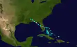
 Season summary map | |
| Seasonal boundaries | |
| First system formed | August 2, 1898 |
| Last system dissipated | November 4, 1898 |
| Strongest storm | |
| Name | "Georgia" |
| • Maximum winds | 130 mph (215 km/h) (1-minute sustained) |
| • Lowest pressure | 938 mbar (hPa; 27.7 inHg) |
| Seasonal statistics | |
| Total storms | 11 |
| Hurricanes | 5 |
| Major hurricanes (Cat. 3+) | 1 |
| Total fatalities | ≥562 total |
| Total damage | At least $5.4 million (1898 USD) |
| Related article | |
The 1898 Atlantic hurricane season ran through the summer and the first half of fall in 1898. The season was fairly active, with 11 storms forming, five of which became hurricanes.
Timeline

Systems
Hurricane One
| Category 1 hurricane (SSHWS) | |
  | |
| Duration | August 2 – August 3 |
|---|---|
| Peak intensity | 80 mph (130 km/h) (1-min); 982 mbar (hPa) |
According to the Weather Bureau, a "feeble disturbance" developed into a tropical storm near West End in the Bahamas early on August 2.[1] Three hours later, the storm made landfall in Hobe Sound, Florida, with winds of 40 mph (65 km/h). The system briefly weakened to a tropical depression on August 2, before re-strengthening into a tropical storm and emerging into the Gulf of Mexico near Tarpon Springs. Later that day, the cyclone intensified quickly, becoming a Category 1 hurricane on the modern-day Saffir–Simpson hurricane wind scale at 23:00 UTC. Simultaneously, the hurricane made a second Florida landfall on St. George Island with winds of 80 mph (130 km/h). After moving inland, it rapidly weakened and dissipated over southwestern Alabama late on August 3.[2]
About 24 hours of heavy rainfall was observed in the Tampa area, which the Morning Tribune noted caused "great damage ... in many places." In the Florida Panhandle, considerable impact was inflicted to crops, turpentine farms, and property. Offshore, three barges, four tugboats, and many sailing crafts sank. Among the capsized vessels was the tugboat Nimrod, with 12 people aboard, all of whom drowned.[1] Four additional deaths occurred offshore, three after the Keyser wrecked and another one after the Herndon floundered.[3]
Hurricane Two
| Category 1 hurricane (SSHWS) | |
  | |
| Duration | August 30 – September 1 |
|---|---|
| Peak intensity | 85 mph (140 km/h) (1-min); 980 mbar (hPa) |
The Weather Bureau noted that a "feeble disturbance" tracked eastward across the Gulf of Mexico and Florida between August 27 and August 29. After reaching a point about 100 mi (160 km) northeast of Cape Canaveral on August 30, the Weather Bureau reported that the disturbance had characteristics of a tropical cyclone.[1] Moving northwestward, the storm soon strengthened into a hurricane and peaked with winds of 85 mph (140 km/h). Around 07:00 UTC on August 31, the hurricane made landfall at the south end of Hilton Head Island, South Carolina. The cyclone weakened to a tropical storm about five hours later and then curved westward. Late on September 1, the storm weakened to a tropical depression and dissipated over Alabama.[2]
Severe damage occurred near the storm's point of landfall, with sustained winds of 84 mph (135 km/h) at Tybee Island, Georgia.[1] Approximately 100 buildings in the vicinity of Savannah at least partially lost their roof and many others experienced at least some degree of damage. The barks Noe and Ragna wrecked along the northeast coast of Georgia.[3] At Port Royal, South Carolina, this storm produced 10.82 in (275 mm) of rain over a 24-hour period, breaking the previous one-day record by 5.89 in (150 mm),[4] with a storm total of 12.4 in (310 mm).[5] Overall, the storm caused approximately $400,000 in damage (1898 USD), nearly all in Savannah and at nearby rice plantations.[6]
Hurricane Three
| Category 1 hurricane (SSHWS) | |
 | |
| Duration | September 3 – September 5 |
|---|---|
| Peak intensity | 80 mph (130 km/h) (1-min); |
On September 3, the ship America encountered this storm,[1] a Category 1 hurricane with winds of 80 mph (130 km/h) about 675 mi (1,085 km) southeast of Cape Race, Newfoundland.[2] Waves waterlogged the ship and eventually caused it to capsized, but the Marengo rescued the crew. The storm moved northeastward and was last encountered by the brig Iddesleigh on September 5,[1] on the same day the Atlantic hurricane best track indicated that the system transitioned into an extratropical cyclone approximately 870 mi (1,400 km) west-southwest of Ireland. The extratropical storm dissipated several hours later.[2]
Hurricane Four
| Category 2 hurricane (SSHWS) | |
 | |
| Duration | September 5 – September 19 |
|---|---|
| Peak intensity | 110 mph (175 km/h) (1-min); 965 mbar (hPa) |
The Windward Islands Hurricane of 1898
Ships first indicated the presence of a tropical storm southwest of Cabo Verde on September 5.[1] The system moved generally westward and intensified into a hurricane late the next day. Early on September 11, the storm peaked as a strong Category 2 hurricane with maximum sustained winds of 110 mph (175 km/h) as it began passing through the Lesser Antilles, first near Barbados and then between Saint Lucia and Saint Vincent several hours later. Thereafter, the hurricane turned northwestward and entered the Caribbean. Around 18:00 UTC on September 12, the cyclone passed just west of Anguilla while traversing the Anegada Passage and re-emerged into the Atlantic. The storm continued northwestward until curving northeastward on September 17. Late on September 19, the system transitioned into an extratropical cyclone about 95 mi (155 km) of the eastern tip of Nova Scotia. The remnants crossed Newfoundland before dissipating over the Labrador Sea on the following day.[2]
Extensive impacts occurred in the Windward Islands. On Barbados, the storm rendered many streets impassable and substantially damaged two stone bridges. Winds downed many trees and thousands of telephone poles. Across the island, 5,062 homes were destroyed and another 2,359 suffered some degree of damage, rendering an estimated 40,000 people homeless. A total of 83 deaths occurred on Barbados and property damage alone reached about $2.5 million.[7] Saint Vincent also experienced significant impact, especially on the westside of the island. Windward Islands governor Cornelius Alfred Moloney noted that "From Buccamont to Kingstown ... everything is destroyed." In towns farther north, such as in Barrouallie, few buildings remained standing. The hurricane destroyed about 2,000 dwellings and damaged numerous others, leaving roughly 15,000 people homeless.[8] Between 200 and 300 fatalities were reported on Saint Vincent.[1] Thus, the National Hurricane Center estimates that this hurricane caused 283 to 383 fatalities,[9] although an additional 18 deaths occurred at Guadeloupe, 9 of them after the Marie Stella capsized and the others due to a landslide burying two residences at Trois-Rivières.[1]
Tropical Storm Five
| Tropical storm (SSHWS) | |
  | |
| Duration | September 12 – September 22 |
|---|---|
| Peak intensity | 60 mph (95 km/h) (1-min); |
The fifth storm formed over the western Caribbean Sea on September 12. It tracked northwestward, and hit the Yucatán Peninsula with 60 mph (97 km/h) winds. Later, the storm traveled north. It hit Louisiana on September 20 with 60 mph (97 km/h) winds and dissipated over Illinois on September 22.
Tropical Storm Six
| Tropical storm (SSHWS) | |
  | |
| Duration | September 20 – September 28 |
|---|---|
| Peak intensity | 60 mph (95 km/h) (1-min); |
The sixth storm formed over the western Caribbean Sea on September 20. It followed a path similar to the fifth storm, tracking northwestward and hitting the Yucatán Peninsula with 60 mph (97 km/h) winds. Later, it traveled north. The system hit the United States near the Texas/Louisiana border on September 28, and dissipated shortly thereafter. Heavy rainfall fell across the central Gulf coast and up the Mississippi Valley, with the highest totals recorded at Pensacola, Florida with 12.61 inches (320 mm) and Sikeston, Missouri where 11.67 inches (296 mm) fell.[10]
Hurricane Seven
| Category 4 hurricane (SSHWS) | |
  | |
| Duration | September 25 – October 6 |
|---|---|
| Peak intensity | 130 mph (215 km/h) (1-min); 938 mbar (hPa) |
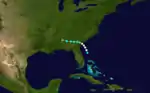
The Georgia Hurricane of 1898
Although the steamship Philadelphia first encountered this storm north of Puerto Rico on September 27, reanalysis by meteorologist C. J. Neumann, et al. in 1993 began the track for this system about 200 mi (320 km) east of Guadeloupe two days earlier.[11][2] Traveling northwest, the storm intensified into a hurricane on September 26 and then into a Category 2 hurricane on September 27. While nearing the coast of the Southeastern United States, the cyclone became a Category 3 hurricane early on October 1 and then a Category 4 hurricane the next day. Around 12:00 UTC on October 2, the storm peaked with maximum sustained winds of 130 mph (215 km/h) and a minimum barometric pressure of 938 mbar (27.7 inHg). The hurricane then made landfall on Cumberland Island, Georgia, four hours later at the same intensity. Early on October 3, the system weakened to a tropical storm over west-central Georgia and a tropical depression over northeastern Alabama several hours later. The cyclone turned northeastward over Indiana and then east-northeastward over Ontario. After emerging into the Gulf of St. Lawrence, the storm struck Newfoundland on October 6 and promptly dissipated.[2]
The First Coast of Florida experienced strong winds and storm surge.[12] Though only minor impacts occurred in Jacksonville, the city lost communications with areas farther north. Nearby, Jacksonville Beach (then known as Pablo Beach) and Mayport reported damage due to storm surge. Farther north, storm surge may have reached 12 ft (3.7 m) in height in Fernandina Beach, flooding much of the town. Damage in Florida was conservatively estimated at $500,000.[12] In Georgia, the storm produced tides up to 18 ft (5.5 m) above mean high water mark at the Sapelo Island Lighthouse. A total of 32 people died in Darien. Storm surge inundated much of Brunswick, with at least 20 streets flooded with 4 to 8 ft (1.2 to 2.4 m) of water, damaging nearly all businesses, warehouses, and docks.[11] Tides and storm surge also caused flooding in the Savannah area, drowning 97 people at one plantation and numerous livestock while ruining about 5,000 barrels of rosin and 60,000 bushels of rice. High tides caused some damage to rice and cotton crops in South Carolina.[12] The cyclone produced heavy rainfall in other areas of the Southeastern United States, especially in western North Carolina.[13] Overall, the storm caused significant damage amounting to around $1.5 million,[12] and 179 fatalities in Georgia.[14]
Tropical Storm Eight
| Tropical storm (SSHWS) | |
  | |
| Duration | September 25 – September 28 |
|---|---|
| Peak intensity | 50 mph (85 km/h) (1-min); 1008 mbar (hPa) |
The eighth storm formed in the Western Caribbean, crossing to the northeast across Cuba, and dissipated over the Bahamas. It formed on September 25 and dissipated on September 28.
Tropical Storm Nine
| Tropical storm (SSHWS) | |
  | |
| Duration | October 2 – October 14 |
|---|---|
| Peak intensity | 70 mph (110 km/h) (1-min); |
A tropical wave forms into a tropical depression on October 2 with winds of 45 MPH. The storm moved across Cuba causing minor flooding and crop damage killing 2, then nearly struck Florida. It then moved to the North Eastern sea and dissipated October 14.
Tropical Storm Ten
| Tropical storm (SSHWS) | |
 | |
| Duration | October 21 – October 23 |
|---|---|
| Peak intensity | 45 mph (75 km/h) (1-min); |
The 10th storm of the season followed a path similar to the 8th storm, forming in the West Caribbean, crossing Cuba, and dissipating over the Bahamas. This storm lasted from October 21 to October 23
Tropical Storm Eleven
| Tropical storm (SSHWS) | |
 | |
| Duration | October 27 – November 4 |
|---|---|
| Peak intensity | 60 mph (95 km/h) (1-min); |
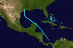
A tropical storm with winds of 60 mph (95 km/h) was first observed near Barbuda early on October 27.[11][2] The storm moved almost due west, passing through the northern Leeward Islands and then just south of Puerto Rico, Hispaniola, and Jamaica before making landfall at Ambergris Caye, British Honduras, with winds of 50 mph (85 km/h) on November 3. The system weakened as it continued westward over Mexico and dissipated on the following day near Coatzacoalcos, Veracruz.[2] Partagás and Diaz noted that "Very little information was found about this storm" and expressed "skepticism regarding the existence and evolution of this storm".[11]
See also
References
- 1 2 3 4 5 6 7 8 9 Partagás, José Fernández; Diaz, Henry F. (1996). Year 1898 (PDF). Atlantic Oceanographic and Meteorological Laboratory (Report). Miami, Florida: National Oceanic and Atmospheric Administration. pp. 9–22. Retrieved September 5, 2023.
- 1 2 3 4 5 6 7 8 9 "Atlantic hurricane best track (HURDAT version 2)" (Database). United States National Hurricane Center. April 5, 2023. Retrieved January 14, 2024.
 This article incorporates text from this source, which is in the public domain.
 - 1 2 Henry, A. J. (August 1898). "The Weather of the Month". Monthly Weather Review. XXVI (8): 350. Bibcode:1898MWRv...26..346H. doi:10.1175/1520-0493(1898)26[346:TWOTM]2.0.CO;2. Retrieved September 5, 2023.
- ↑ "Heavy Rain During Hurricane at Port Royal, South Carolina". Monthly Weather Review. XXVI (8): 364. August 1898. Bibcode:1898MWRv...26Q.364.. doi:10.1175/1520-0493(1898)26[364a:HRDHAP]2.0.CO;2. Retrieved December 6, 2023.
- ↑ United States Army Corps of Engineers (1945). Storm Total Rainfall In The United States. United States Department of War. p. SA 3–6.
- ↑ Bigelow, H. F. (August 1898). "Forecasts and Warnings" (PDF). Monthly Weather Review. XXVI (8): 344. Bibcode:1898MWRv...26..343B. doi:10.1175/1520-0493(1898)26[343b:FAW]2.0.CO;2. Archived from the original (PDF) on March 3, 2017. Retrieved December 6, 2023.
- ↑ Garriott, Edward B. (August 1898). "Forecasts and Warnings". Monthly Weather Review. XXVI (8). Bibcode:1898MWRv...26..391G. doi:10.1175/1520-0493(1898)26[391b:FAW]2.0.CO;2. Retrieved September 3, 2023.
- ↑ "Extent of the disaster". The Birmingham Gazette. September 16, 1898. p. 5. Retrieved September 5, 2023 – via Newspapers.com.

- ↑ Rappaport, Edward N.; Partagás, José Fernández; Beven, Jack (April 22, 1997). The Deadliest Atlantic Tropical Cyclones, 1492-1996 (Report). National Hurricane Center. Retrieved September 5, 2023.
- ↑ United States Army Corps of Engineers (1945). Storm Total Rainfall In The United States. War Department. p. LMV 1–3.
- 1 2 3 4 Partagás, José Fernández; Diaz, Henry F. (1996). Year 1898 (PDF). Atlantic Oceanographic and Meteorological Laboratory (Report). Miami, Florida: National Oceanic and Atmospheric Administration. pp. 23–38. Retrieved September 5, 2023.
- 1 2 3 4 Garriott, Edward B. (October 1898). "Forecasts and Warnings". Monthly Weather Review. XXVI (10). Bibcode:1898MWRv...26..493G. doi:10.1175/1520-0493(1898)26[493b:FAW]2.0.CO;2. Retrieved September 7, 2023.
- ↑ United States Army Corps of Engineers (1945). Storm Total Rainfall In The United States. War Department. p. SA 3–7.
- ↑ Sandrik, Al; Landsea, Christopher W. (May 2003). Chronological Listing of Tropical Cyclones affecting North Florida and Coastal Georgia 1565-1899 (Report). National Weather Service Jacksonville, Florida. Retrieved September 7, 2023.