Porangatu | |
|---|---|
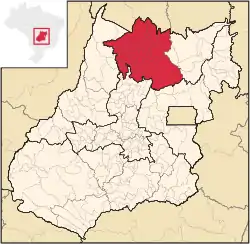 Location in Goias state | |
| Country | Brazil |
| State | Goiás |
| Mesoregion | Norte Goiano |
| Municipalities | 19 |
| Area | |
| • Total | 35,287 km2 (13,624 sq mi) |
| Population (2007) | |
| • Total | 220,794 |
| • Density | 6.3/km2 (16/sq mi) |
The Porangatu Microregion is a statistical region created by IBGE (Instituto Brasileiro de Geografia e Economia) in north-central Goiás state, Brazil. The most important city is Porangatu.
Municipalities
The microregion consists of the following municipalities:[1]
See also
References
- ↑ Instituto Brasileiro de Geografia e Estatística, territorial division.
13°26′27″S 49°08′56″W / 13.44083°S 49.14889°W
This article is issued from Wikipedia. The text is licensed under Creative Commons - Attribution - Sharealike. Additional terms may apply for the media files.