| Salhyr Салгір (Ukrainian) Salğır (Crimean Tatar) Салгир (Russian) Salgir | |
|---|---|
 Salhyr River flowing through Simferopol | |
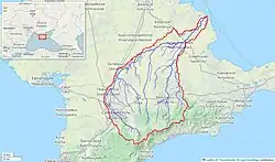 Salhyr River watershed (Interactive map) | |
| Physical characteristics | |
| Source | |
| • location | Chatyrdag, Crimea (Territory of Ukraine, occupied by Russia[1] ) |
| Mouth | |
• location | Syvash of the Azov Sea |
| Length | 204 km (127 mi) |
| Basin size | 3,750 km2 (1,450 sq mi) |
| Discharge | |
| • average | 2 m3/s (71 cu ft/s) |
The Salhyr[lower-alpha 1] or Salgir is the longest river of the Crimean Peninsula. Its length is 204 km, and its drainage basin is 3,750 km². The average discharge of the water is 2 m³/s.[2]
It is formed in the Chatyr-Dag mountains southeast of Simferopol, passes that town, and flows north and increasingly east to reach the Syvash of the Azov Sea. Along the way, the river passes through the North Crimean Canal, previously a large affluent water from Byuk Karasu River up north Novoivanovka (Nizhnegorsk). It is mainly used for hydroelectricity and agricultural usage.
Notes
References
- ↑ This place is located on the Crimean peninsula, which is internationally recognized as part of Ukraine, but since 2014 under Russian occupation. According to the administrative-territorial division of Ukraine, there are the Ukrainian divisions (the Autonomous Republic of Crimea and the city with special status of Sevastopol) located on the peninsula. Russia claims these as federal subjects of the Russian Federation (the Republic of Crimea and the federal city of Sevastopol).
- ↑ Simferopol. UKRTravel. Accessed April 17, 2012.
This article is issued from Wikipedia. The text is licensed under Creative Commons - Attribution - Sharealike. Additional terms may apply for the media files.