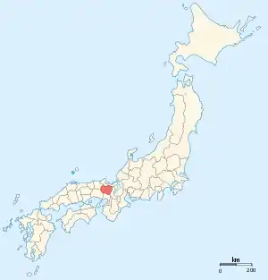
Tanba[1] Province (丹波国, Tanba no kuni) was a province of Japan in the area of central Kyoto and east-central Hyōgo Prefectures.[2] Tanba bordered on Harima, Ōmi, Settsu, Tajima. Tango, Wakasa, and Yamashiro provinces. Its abbreviated form name was Tanshū (丹州). In terms of the Gokishichidō system, Tanba was one of the provinces of the San'indō circuit. Under the Engishiki classification system, Tanba was ranked as one of the "superior countries" (上国) in terms of importance, and one of the "near countries" (近国) in terms of distance from the capital. The provincial capital is believed to have been located in what is now the city of Kameoka, although the exact location remains uncertain. The ichinomiya of the province is the Izumo-daijingū also located in Kameoka. The province had an area of 1,283.43 square kilometres (495.54 sq mi).

History
Before the establishment of the Ritsuryō system, the area was under control of the Tanba Kokuzō and included both the Tanba and Tango areas. The province of Tango was created in 713 during the reign of Empress Genmei by separating the northern five districts (Kasa District, Yoza District, Tamba District (later Naka District), Takeno District, and Kumano District) into "Tango", and the districts closer to the capital as "Tanba".[3] The Tanba area is rugged, and can be roughly divided into several river basins separated by mountains. For this reason, historically the province has been difficult to govern as a whole. On the other hand, its proximity to the capital gave it a strategic importance. During the Muromachi period, the Hosokawa clan were the shugo of the province, but governed through their proxies, the Naito clan. During the late Sengoku period, the province was conquered by Akechi Mitsuhide, and after his defeat by Toyotomi Hideyoshi at the Battle of Yamasaki in the aftermath of the assassination of Oda Nobunaga, it was governed by a succession of relatives of the Toyotomi clan. In the Edo Period, Tanba was governed by a mosaic of mostly fudai daimyō domains, who were considered more reliable by the Tokugawa shogunate and who could be called upon when necessary for the defense of Kyoto and Osaka.
| Name | Clan | Type | kokudaka |
|---|---|---|---|
| Aoyama clan | Fudai | 60,000 koku | |
| Katanobara-Matsudaira clan | Fudai | 50,000 koku | |
| Oda clan | Tozama | 36,000 koku | |
| Kutsuki clan | Fudai | 32,000 koku | |
| Koide clan | Fudai | 24,000 koku | |
| Kuki clan | Tozama | 19,500 koku | |
| Tani clan | Tozama | 10.000 koku | |
Meiji period
Following the Meiji restoration, Tanba was divided into six districts. [4] Per the early Meiji period Kyudaka kyuryo Torishirabe-chō (旧高旧領取調帳), an official government assessment of the nation’s resources, the province had 970 villages with a total kokudaka of 331,954 koku.
| District | kokudaka | Controlled by | at present | Currently |
|---|---|---|---|---|
| Kuwata (熊野郡) | 56,227 koku | 218 villages: Tenryō, Imperial family, Kuge, Tanba-Kameyama, Sonobe, Sasayama, Takatsuki | most of Kameoka, parts of Nantan, Kyoto, Takatsuki and Toyono | |
| Funai (船井郡) | 52,140 koku | 210 villages: Tenryō, Imperial Family, Sonobe, Tanba-Kameyama, Sasayama, Ayabe Tsurumaki | part of Nantan and Kameoka | |
| Ikaruga (何鹿郡) | 49,525 koku | 136 villages: Tenryō, Ayabe, Yamake, Sonobe, Kaibara, Sasayama, Yunagaya, Okabe | dissolved | Fukuchiyama, small part of Ayabe |
| Amata (天田郡) | 52,059 koku | 119 villages: Tenryō, Fukuchiyama, Ayabe, Iino,Tsurumaki, Kaibara, Sasayama, Okabe | dissolved | Fukuchiyama |
| Hikami (氷上郡) | 68,546 koku | 172 villages: Tenryō , Kuge, Kaibara, Tanba-Kameyama, Yunagaya, Tsurumaki, Sanda, Yamakami | dissolved | Tanba |
| Taki (多紀郡) | 53,453 koku | 115 villages: Sasayama | dissolved | Tamba-Sayayama, Hyogo |
Gallery
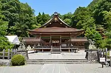 Izumo-daijingū, ichinomiya of the province
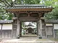 Ruins of Tanba Kokubun-ji
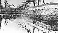 Sasayama Castle
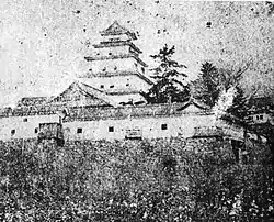 Kameyama Castle
Notes
- ↑ Spelling note: A modified Hepburn romanization system for Japanese words is used throughout Western publications in a range of languages, including English. Unlike the standard system, the "n" is maintained even when followed by "homorganic consonants" (e.g., shinbun, not shimbun).
- ↑ Nussbaum, Louis-Frédéric. (2005). "Tanba" in Japan Encyclopedia, p. 943, p. 943, at Google Books.
- ↑ Titsingh, Isaac. (1834). Annales des empereurs du japon, p. 64., p. 64, at Google Books
- ↑ Nussbaum, "Provinces and prefectures" at p. 780.
References
- Nussbaum, Louis-Frédéric and Käthe Roth. (2005). Japan encyclopedia. Cambridge: Harvard University Press. ISBN 978-0-674-01753-5; OCLC 58053128
- Titsingh, Isaac. (1834). Annales des empereurs du Japon (Nihon Ōdai Ichiran). Paris: Royal Asiatic Society, Oriental Translation Fund of Great Britain and Ireland. OCLC 5850691.
External links
![]() Media related to Tamba Province at Wikimedia Commons
Media related to Tamba Province at Wikimedia Commons