| Taugl Tauglbach | |
|---|---|
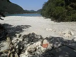 Gravel bank of the Tauglbach discharging into the Hintersee | |
| Location | |
| Country | Austria |
| State | Salzburg |
| Physical characteristics | |
| Source | |
| • location | Near the mountains Gennerhorn and Gruberhorn |
| Mouth | |
• location | Lake Hintersee |
• coordinates | 47°44′49″N 13°15′09″E / 47.7469°N 13.2525°E |
| Length | ~ 10 km (6.2 mi) |
| Basin features | |
| Progression | Almbach→ Salzach→ Inn→ Danube→ Black Sea |
The Taugl or also Tauglbach is a river of the State of Salzburg, Austria.
The Taugl rises near the mountains Gennerhorn and Gruberhorn (in the Salzkammergut Mountains) at a height of approx. 1,700 m (AA). The river flows from south to north into the lake Hintersee, which is drained by the Almbach. The river has a length of approx. 10 km (6.2 mi), of which 8 km (5.0 mi) is through a ravine. It is therefore classified as a dangerous white water river. The water quality is classified as A grade.
This article is issued from Wikipedia. The text is licensed under Creative Commons - Attribution - Sharealike. Additional terms may apply for the media files.