Val-d'Or Airport | |||||||||||
|---|---|---|---|---|---|---|---|---|---|---|---|
 | |||||||||||
| Summary | |||||||||||
| Airport type | Public | ||||||||||
| Operator | Aéroport régional de Val-d'Or | ||||||||||
| Location | Val-d'Or, Quebec | ||||||||||
| Time zone | EST (UTC−05:00) | ||||||||||
| • Summer (DST) | EDT (UTC−04:00) | ||||||||||
| Elevation AMSL | 1,105 ft / 337 m | ||||||||||
| Coordinates | 48°03′12″N 077°46′58″W / 48.05333°N 77.78278°W | ||||||||||
| Website | www.arvo.qc.ca | ||||||||||
| Map | |||||||||||
 CYVO  CYVO | |||||||||||
| Runways | |||||||||||
| |||||||||||
| Statistics (2012) | |||||||||||
| |||||||||||
Val-d'Or Airport (IATA: YVO, ICAO: CYVO) is located 2.5 nautical miles (4.6 km; 2.9 mi) south of Val-d'Or, Quebec, Canada.
Airlines and destinations
| Airlines | Destinations |
|---|---|
| Air Creebec[4] | Chibougamau, Chisasibi, Eastmain, Kuujjuarapik, Montreal–Trudeau, Nemaska, Waskaganish, Wemindji |
| Air Inuit | Charter: Kattiniq/Donaldson |
| Nolinor Aviation | Charter: Meadowbank Gold Mine, Rankin Inlet |
| PAL Airlines | Montreal–Trudeau |
Accidents and incidents
- On 19 June 1970, Douglas C-47A CF-AAC of Austin Airways was written off in an accident.[5]
- On 13 March 1994, during a flight between Val-d'Or and Montreal Dorval a Canadian Airlines (Inter-Canadien) ATR 42-300 registered as C-GIQV suffered a propeller blade failure at 17,000 ft (5,182 m). The aircraft landed safely at Montreal.[6]
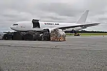 First Air Boeing 767 at Val-d'Or Airport
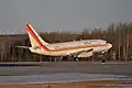
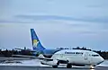 Canadian North Boeing 737-200 in Val-d'Or
See also
References
- ↑ Canada Flight Supplement. Effective 0901Z 16 July 2020 to 0901Z 10 September 2020.
- ↑ Synoptic/Metstat Station Information
- ↑ Total aircraft movements by class of operation — NAV CANADA flight service stations
- ↑ "Flight schedule". Air Creebec. Retrieved 4 January 2024.
- ↑ "CF-AAC Accident description". Aviation Safety Network. Retrieved 20 October 2010.
- ↑ "Aviation Reports - 1994 - A94Q0037". Transportation Safety Board of Canada. Retrieved 18 April 2011.
External links
Wikimedia Commons has media related to Val-d'Or Airport.
- Past three hours METARs, SPECI and current TAFs for Val-d'Or Airport from Nav Canada as available.
| By name | |
|---|---|
| By location indicator | |
| By province/territory | |
| By area | |
| National Airports System | |
| Related | |
| |
This article is issued from Wikipedia. The text is licensed under Creative Commons - Attribution - Sharealike. Additional terms may apply for the media files.