3

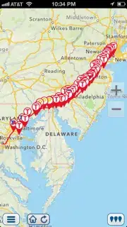
I'm an app on iOS, which has Trip Planner. For example I'm using google direction API to get route from New York to Boston. I have 50 different latitude longitude to make polylines on the map. After that I need to get places on this route which I can visit on the way to Boston.

Google directions API gives me:

latitude = "30.308399"; longitude = "-89.748299";
latitude = "30.310930"; longitude = "-89.818604";
latitude = "30.350050"; longitude = "-89.916054";
latitude = "30.432850"; longitude = "-90.098549";
....

Right now for each point I do search in mysql database to get closest places:

select id,title,type_id,service_id,latitude,longitude,state,city,zip,address, ( 3959 * acos( cos( radians(31.72723) ) * cos( radians(latitude ) ) * cos( radians( longitude ) - radians(-106.3047)) + sin( radians(31.72723) ) * sin( radians(latitude ) ) ) ) AS distance from places distance <= 10 order by distance ASC limit 10

But if this trip from New York to San Francisco, I will have 800 points, I would to make 800 query to database which takes more than 2 seconds in total. And I have 7 different tables, it would be 14 seconds.

What is the best to do if?

Example

Community
  • 1
  • 1
Dark Matter
  • 3,638
  • 3
  • 14
  • 14
  • How much points inside database? – Толя Feb 20 '13 at 06:39
  • 7 tables in total have 80k places – Dark Matter Feb 20 '13 at 06:40
  • You need to make places in DB more organized..may be by running k-means clustering and dividing them into different clusters..then instead of searching each place you can search by each cluster..size of the cluster..should depend on level of zoom.. – Shivam Feb 20 '13 at 06:52
  • possible duplicate of [Algorithm to find all Latitude Longitude locations within a certain distance from a given Lat Lng location](http://stackoverflow.com/questions/5031268/algorithm-to-find-all-latitude-longitude-locations-within-a-certain-distance-fro) – raisercostin Dec 18 '14 at 09:56

3 Answers3

2

Here's one way to make it faster:

(1) Put indexes in the table for latitude and longitude.

(2) In the query, select first only those places within a horizontal and vertical distance of the point on the route, close enough to be interesting. Select by latitude range and longitude range.

(3) Then sort those points by distance, either inside or outside the query.

xpda
  • 15,585
  • 8
  • 51
  • 82
1

Best I can suggest this is Voronoi diagram. But it hard to implement.

Notes: As you have only 80k points, you may cache all this points inside application and return from application required points.

Толя
  • 2,839
  • 15
  • 23
-1

Try putting in a minimum distance clause, Where Diatance > 100 etc.

This is known as a conical scan. You start with a low resolution and then keep increasing as you get closer.

Srikant Krishna
  • 881
  • 6
  • 11