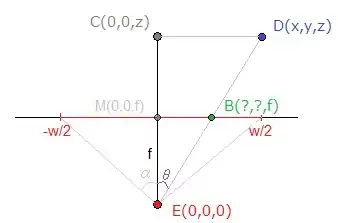
I'm still implementing a perspective projection for my augmented reality application. I've already asked some questions about the viewport-calculation and other camera stuff, which is explained from Aldream in this thread
However, I don't get any useful value at the moment and I think this depends on my calculation of the cartesian coordinate space.
I had some different ways to transform latitude,longitude and altitude to a cartesian coordinate space, but nothing of them seems to work properly. Currently I'm using ECEF(earth centered), but I also tried different calculations like a combination of the haversine-formula and trigonometry (to calculate x and y from the distance and the bearing between two points).
So my question is:
How does the cartesian coordinate space affect my perspective projection? Where do I have to "compensate" my units?(When I'm using meter or centimeter for example)?
Lets say I'm using ECEF, than I get values in meter, so for example, my camera is at (0,0,2m height) and my point is at (10,10,0). Now I can easily use the function mentioned on wikipedia and afterwards using the conversion of dx,dy,dz explained in my other thread (mentioned above). What I still don't get: How does this projection "know" what my units in the coordinate system are? I think this is the mistake I'm currently doing. I don't handle the units of my coordinate system and therefore, cannot get any good value from my projection.
When I'm using a coordinate system with centimeter as unit, all of my values from my perspective projection are increasing. Where do I have to "resolve" this unit-problem? Do I have to "transform" my camera-width and camera-height from pixel to meter? Do I have to convert the coordinate system to pixel? Which coordinate-system should be used to handle this situation? I hope you can understand my problem.
Edit:I solved it myself. I've changed my coordinate system from ecef to a own system (using haversine and bearing and then calculating x,y,z) and now I get good values! :)