//the only global variable
//SM will become the SnapManager instance.
var SM = null;
google.maps.event.addDomListener(window, "load", function () {
//we will center the map here
var vancouver = {
lat: 49.269858,
lng: -123.137283
}
//granville island coordinates.
//you should be fetching your coordinates from your server
var granville_coords = [
{lat: 49.27158485202591, lng: -123.13729763031006},
{lat: 49.27277488695786, lng: -123.13691139221191},
{lat: 49.27316689217891, lng: -123.13613891601562},
{lat: 49.27319489243262, lng: -123.13474416732788},
{lat: 49.27248088099777, lng: -123.13384294509888},
{lat: 49.2696667352996, lng: -123.13049554824829},
{lat: 49.268546632648494,lng: -123.13055992126465},
{lat: 49.268350612069995,lng: -123.13066720962524},
{lat: 49.2684906268484, lng: -123.13146114349365},
{lat: 49.268546632648494,lng: -123.13249111175537},
{lat: 49.26888266611402, lng: -123.13347816467285},
{lat: 49.26889666745873, lng: -123.13401460647583},
{lat: 49.2706328034105, lng: -123.1368041038513 }
];
//coordinates of blocks just east of burrard.
var burrard_coords = [
{lat: 49.267972570183545, lng: -123.145751953125},
{lat: 49.2679445669656, lng: -123.14085960388184},
{lat: 49.27032478374826, lng: -123.14077377319336},
{lat: 49.27138884351881, lng: -123.14176082611084},
{lat: 49.27309689147504, lng: -123.14356327056885},
{lat: 49.27267688516586, lng: -123.14467906951904},
{lat: 49.27152884967477, lng: -123.14553737640381},
{lat: 49.269834748503946, lng: -123.1459450721740}
];
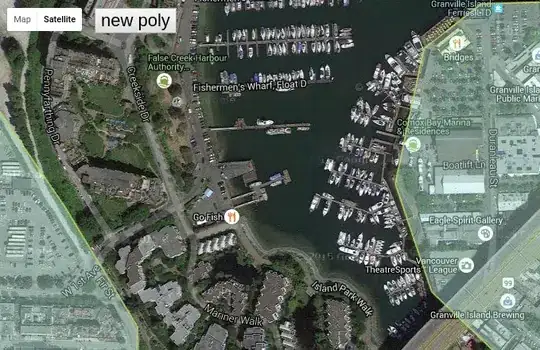
//make the satellite view google map, center it in Vancouver.
map = new google.maps.Map(document.getElementById("map_div"), {
center: new google.maps.LatLng(vancouver.lat, vancouver.lng),
zoom: 16,
mapTypeId: google.maps.MapTypeId.HYBRID
});
//this style is easier on the eyes than the default black.
//BADASS and COFFEE hex to the rescue.
var polystyle = {
strokeColor: '#BADA55',
strokeOpacity: 0.8,
strokeWeight: 2,
fillColor: '#C0FFEE',
fillOpacity: 0.35
}
//options for granville polygon.
//SNAPABLE = TRUE
var poly1_opts = $.extend({
paths: granville_coords,
map: map,
snapable: true
}, polystyle);
//options for burrard polygon
//SNAPABLE not present (false)
var poly2_opts = $.extend({
paths: burrard_coords,
map: map
}, polystyle);
//let's make the polygons
var granville = new google.maps.Polygon(poly1_opts);
var burrard = new google.maps.Polygon(poly2_opts);
/*
For demo purposes, lets just put two gmaps Polys into the polygon array.
For your application purposes, you would populate this array with
all of the polygons you want to snap to - likely driven from the DB.
*/
polygons = [granville, burrard];
/*
Now, we make the SnapManager.
See http://stackoverflow.com/a/33338065/568884 for API
Will be transferred to Github soon.
*/
SM = PolySnapper({
map: map,
marker: new google.maps.Marker(),
threshold: 20,
keyRequired: false,
polygons: polygons,
polystyle: polystyle,
hidePOI: true,
onEnabled: function(){
console.log("enabled")
},
onDisabled: function(){
console.log("disabled")
}
});
//add the buttons initial state on top of the map.
renderCpanel(false);
});
//when user clicks log poly button, pull the poly out of the manager and console.log it.
$(document).on("click", "#query", function(){
console.log( SM.poly().getPath().getArray() );
});
//just a small render function to re-draw the buttons whenever the enabled state is flipped on and off.
function renderCpanel(drawing){
var t = $("#control-panel").html();
var html = _.template(t, {drawing: drawing});
$("#cp-wrap").html(html);
}
//attach the click handlers to the button. #cp-wrap is never added or removed
//from the DOM, so its safe to bind the listeners to it.
$("#cp-wrap").on("click", "button", function(){
var action = $(this).data("action");
if (action == 'new') SM.enable();
else if(action == 'query') console.log( SM.polygon() )
else SM.disable();
renderCpanel( (action == 'new') );
});
body {
  margin: 0;
  padding: 0;
  font: 12px sans-serif;
}
#cp-wrap{
    position: absolute;
    top: 10px;
    left:120px;
    background-color:white;
}

#cp-wrap button{
    font-size: 22px;
}
<script src="https://rawgit.com/jordanarseno/polysnapper/master/polysnapper.js"></script>
<script src="http://underscorejs.org/underscore-min.js"></script>
<script src="https://ajax.googleapis.com/ajax/libs/jquery/2.1.1/jquery.min.js"></script>
<script src="https://maps.google.com/maps/api/js?.js"></script>
<div style='position:relative;'>
    <div id="map_div" style="height: 600px; width:100%;"></div>
    <div id='cp-wrap'></div>
</div>

<script id='control-panel' type='text/template'>
    <% if(drawing) { %>
        <button data-action='cancel' >cancel</button>
        <button data-action='query' >log poly</button>
    <% } else { %>
        <button data-action='new' >new poly</button>
    <% } %>
</script>