I am new to Spatialite. I have following query:
select A.*
from linka as A, pointa as B
where Contains(Buffer(B.Geometry, 100), A.Geometry)
I actually want to create 100 meters buffer and get to know which are the link's are contained by it.
I can able to find the inserted '100' is actually degree value and it's giving me output which are coming in this range.
I can put the degree value also in my query but the transformation from degree to meters/kilometers is not same all around the world. I gone through many sites and able to know 1 degree = 110 KM approx. but from GIS expert and some reference sites also get to know at each pole on earth it's different.
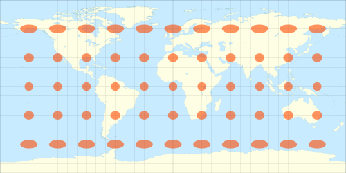
For instance, the difference at Alta/Norway between metrical x and y for planar approximation is 34 km in x direction equal 111 km in y direction. The buffer looks similar to this while using geographic coordinates:
http://extremelysatisfactorytotalitarianism.com/blog/wp-content/uploads/2010/08/tissot_indicatrix_equirectangular_proj.png
I build software which convert geographical data to geometrical (X, Y -coordinate format) data and make transformation where Spatiallite can understand.
I also trying to read regarding SRID things but not able to understand how to insert it into my query.