I use Mike Bostock's code to Center a map in d3 given a geoJSON object.
The important part of the code is this:
var width = 960,
    height = 500;

var svg = d3.select("body").append("svg")
    .attr("width", width)
    .attr("height", height);

d3.json("/d/4090846/us.json", function(error, us) {
  var states = topojson.feature(us, us.objects.states),
      state = states.features.filter(function(d) { return d.id === 34; })[0];

/* ******************* AUTOCENTERING ************************* */
// Create a unit projection.
var projection = d3.geo.albers()
    .scale(1)
    .translate([0, 0]);

// Create a path generator.
var path = d3.geo.path()
    .projection(projection);

// Compute the bounds of a feature of interest, then derive scale & translate.
var b = path.bounds(state),
    s = .95 / Math.max((b[1][0] - b[0][0]) / width, (b[1][1] - b[0][1]) / height),
    t = [(width - s * (b[1][0] + b[0][0])) / 2, (height - s * (b[1][1] + b[0][1])) / 2];

// Update the projection to use computed scale & translate.
projection
    .scale(s)
    .translate(t);
/* ******************* END *********************************** */

// Landmass
  svg.append("path")
      .datum(states)
      .attr("class", "feature")
      .attr("d", path);

// Focus
  svg.append("path")
      .datum(state)
      .attr("class", "outline")
      .attr("d", path);
});
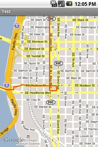
For example, bl.ocks.org/4707858 zoom in such:
How to center and zoom on the target topo/geo.json AND adjust the svg frame dimensions so it fit a 5% margin on each size ?