I've been working on a map utilizing Google Maps Javascript API (V3) where, on click, a circle (polygon) is drawn based on the click's location. On the same map, I have another polygon that I would consider a boundary. When I click within that boundary, the polygon is created, but it overlaps. I would like it so that the polygon is drawn within the boundary without the overlap.
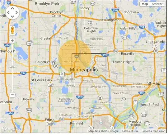
Below is a picture of what the script currently does:
This is what I would like the script to do:
Below is what I have so far:
<html>
<head>
<script type="text/javascript" src="http://maps.google.com/maps/api/js?libraries=geometry"></script>
<script type="text/javascript">

var map;
var twinCities = new google.maps.LatLng(44.9833,-93.2667);
var polys = [];
var start = 0;
var end = 360;
var radiusMeters = 3218;
var testCSABoundary;
var bounds = [
    new google.maps.LatLng(45.00651098836318, -93.29441785812378),
    new google.maps.LatLng(45.00651098836318, -93.20996046066284),
    new google.maps.LatLng(44.956242131334214, -93.20996046066284),
    new google.maps.LatLng(44.956242131334214, -93.29441785812378),
];

function initialize() {
    var mapOptions = {
        zoom: 11,
        center: twinCities,
    };

    map = new google.maps.Map(document.getElementById("map-canvas"), mapOptions);

    google.maps.event.addListener(map, 'click', function(e) {

        createCircles(e.latLng);

    });

    testCSABoundary = new google.maps.Polygon({
        strokeColor: '#000000',
        strokeOpacity: 1.00,
        strokeWeight: 2,
        fillOpacity: 0.00,
        map: map,
        center: twinCities,
        clickable: false,
        paths: bounds,
    });
}

function createCircles(position) {

    var twopath = getArcPath(position, radiusMeters, start, end);

    var twopathRing = new google.maps.Polygon({
        paths: twopath,
        strokeColor: '#fead00',
        strokeOpacity: 0.45,
        strokeWeight: 1,
        fillColor: '#fead00',
        fillOpacity: 0.45,
        map: map,
        center: position,
    });

}

function getArcPath(center, radiusMeters, startAngle, endAngle, direction) {
    var point, previous,
        atEnd = false,
        points = [],
        a = startAngle,
        string = "new google.maps.LatLng";
    while (true) {
        point = google.maps.geometry.spherical.computeOffset(center, radiusMeters, a);
        points.push(point);
        if (a == endAngle){
            break;
        }
        a++;
        if (a > 360) {
            a = 1;
        }
    }
    if (direction == 'counterclockwise') {
        points = points.reverse();
    }

    for (var i = 0; i < points.length; i++) {
        if (google.maps.geometry.poly.containsLocation(points[i],testCSABoundary) == false) {
            points.splice(i ,1);
        }
    }

    return points;
}

google.maps.event.addDomListener(window, 'load', initialize);

</script>

<style>

body {
    font-family: sans-serif;
    margin: 0px;
    padding: 0px;
}

#map-canvas {
    border: 1px solid black;
    width: 100%;
    height: 100%;
    margin-left: auto;
    margin-right: auto;
}

</style>

</head>
<body style="width: 600; height: 480;">
  <div id="map-canvas"></div><br>
</body>
</html>
I've tried using google.maps.geometry.poly.containsLocation within the getArcPath function in a for loop, where if it returns false, it removes that point from the points array. However, this doesn't appear to work.
In thinking about this for loop a bit more, I've come to the conclusion that this may not be the right solution to this problem any way as it won't draw the polygon properly causing a clip within the drawn boundary. I'm thinking that I may need to use a combination of the contains() and intersects() functions to get this to work properly but I'm not sure where to start in implementing these two functions.
* Additional information added below on 5/26/2015 *
After taking a look at the JSTS library, I've come up with some pseudo code but I need some verification that I'm on the right track. From what I've been reading, it appears that I need to convert my coordinates from Google Maps latitude and longitude to JSTS coordinates and then back to Google Maps after the script is ran. Below is my pseudo code:
var jstsBoundary = convert2jsts(bounds);
var jststwopath = convert2jsts(twopath);

for (var i = 0; i < jststwopath.length; i++) {
    if(containsLocation(jststwopath[i], jstsBoundary) == false) {
        newPoint = latlng on jstsBoundary nearest to jststwopath[i];
        jststwopath.splice(i, 1, newPoint);
    }
}

var gmapstwopath = convert2gmaps(jststwopath);

function convert2jsts(points) {
    //convert points from gmaps coords to jsts coords;
    return(jstspoints);
}

function convert2gmaps(points) {
    //convert points from jsts coords to gmaps coords;
    return(gmapspoints);
}
Many thanks in advance.