100

is it possible to limit Google map v3 to a certain area? I want to allow displaying only some area (e.g. a country) and disallow the user to slide elsewhere. Also I want to restrict the zoom level - e.g. only between levels 6 and 9. And I want to use all the base map types.

Is there any way to achieve this?

I had a partial success with limiting zoom level by using StyledMap, but I succeeded only with restricting ROADMAP, I wasn't able to limit zoom on other basic types this way.

Thanks for any help

Daniel Vassallo
  • 337,827
  • 72
  • 505
  • 443
Tomik
  • 23,857
  • 8
  • 121
  • 100

12 Answers12

183

Better way to restrict zoom level might be to use the minZoom/maxZoom options rather than reacting to events?

var opt = { minZoom: 6, maxZoom: 9 };
map.setOptions(opt);

Or the options can be specified during map initialization, e.g.:

var map = new google.maps.Map(document.getElementById('map-canvas'), opt);

See: Google Maps JavaScript API V3 Reference

martin
  • 93,354
  • 25
  • 191
  • 226
ChrisV
  • 8,748
  • 3
  • 48
  • 38
119

You can listen to the dragend event, and if the map is dragged outside the allowed bounds, move it back inside. You can define your allowed bounds in a LatLngBounds object and then use the contains() method to check if the new lat/lng center is within the bounds.

You can also limit the zoom level very easily.

Consider the following example: Fiddle Demo

<!DOCTYPE html>
<html> 
<head> 
   <meta http-equiv="content-type" content="text/html; charset=UTF-8"/> 
   <title>Google Maps JavaScript API v3 Example: Limit Panning and Zoom</title> 
   <script type="text/javascript" 
           src="http://maps.google.com/maps/api/js?sensor=false"></script>
</head> 
<body> 
   <div id="map" style="width: 400px; height: 300px;"></div> 

   <script type="text/javascript"> 

   // This is the minimum zoom level that we'll allow
   var minZoomLevel = 5;

   var map = new google.maps.Map(document.getElementById('map'), {
      zoom: minZoomLevel,
      center: new google.maps.LatLng(38.50, -90.50),
      mapTypeId: google.maps.MapTypeId.ROADMAP
   });

   // Bounds for North America
   var strictBounds = new google.maps.LatLngBounds(
     new google.maps.LatLng(28.70, -127.50), 
     new google.maps.LatLng(48.85, -55.90)
   );

   // Listen for the dragend event
   google.maps.event.addListener(map, 'dragend', function() {
     if (strictBounds.contains(map.getCenter())) return;

     // We're out of bounds - Move the map back within the bounds

     var c = map.getCenter(),
         x = c.lng(),
         y = c.lat(),
         maxX = strictBounds.getNorthEast().lng(),
         maxY = strictBounds.getNorthEast().lat(),
         minX = strictBounds.getSouthWest().lng(),
         minY = strictBounds.getSouthWest().lat();

     if (x < minX) x = minX;
     if (x > maxX) x = maxX;
     if (y < minY) y = minY;
     if (y > maxY) y = maxY;

     map.setCenter(new google.maps.LatLng(y, x));
   });

   // Limit the zoom level
   google.maps.event.addListener(map, 'zoom_changed', function() {
     if (map.getZoom() < minZoomLevel) map.setZoom(minZoomLevel);
   });

   </script> 
</body> 
</html>

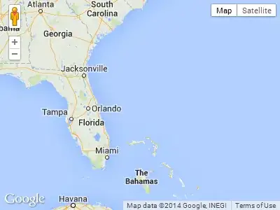
Screenshot from the above example. The user will not be able to drag further south or far east in this case:

Google Maps JavaScript API v3 Example: Force stop map dragging

Tushar Gupta - curioustushar
  • 58,085
  • 24
  • 103
  • 107
Daniel Vassallo
  • 337,827
  • 72
  • 505
  • 443
  • 2
    The decision doesn't look clean. Why `if (x < minX) x = minX;` and `if (x > maxX) x = maxX;` don't exclude each other? Why do you center the canvas on minX/maxX and maxX/maxY coordinates though they aren't coordinates of center? – Alexander Palamarchuk Aug 19 '12 at 11:06
  • 1
    Instead of `dragend` event you could use `draggable: false` on map instance ([working example](http://jsfiddle.net/32pc6f5v/)) – machineaddict Sep 24 '14 at 11:43
  • This is not a good technique to use "zoom_changed" event to restrict the user. Because first time it will always goes beyond to the min level and then using your code, you're setting the min zoom again which will flikr the screen. – Jitendra Pancholi Jul 16 '15 at 04:50
  • check http://www.zillow.com/homes/for_sale/days_sort/37.174509,-94.312091,37.128332,-94.396205_rect/13_zm/9008955a73X1-CRjs2twnqatmst_11118l_crid/ They have done it in correct way, not sure how. – Jitendra Pancholi Jul 16 '15 at 04:51
  • also see this https://developers.google.com/maps/documentation/javascript/reference#MapOptions – Jitendra Pancholi Jul 16 '15 at 05:00
  • 1
    This worked perfectly for me if i changed to the `center_changed` event instead of `dragend`. – Johan B Jan 20 '17 at 09:53
  • I would suggest change `setCenter` to `panTo` in this line ```map.setCenter(new google.maps.LatLng(y, x));``` but I noticed a misbehavior while trying to pan the map near the limits (strict bounds). – ed1nh0 Sep 19 '18 at 13:14
23

Good news. Starting from the version 3.35 of Maps JavaScript API, that was launched on February 14, 2019, you can use new restriction option in order to limit the viewport of the map.

According to the documentation

MapRestriction interface

A restriction that can be applied to the Map. The map's viewport will not exceed these restrictions.

source: https://developers.google.com/maps/documentation/javascript/reference/map#MapRestriction

So, now you just add restriction option during a map initialization and that it. Have a look at the following example that limits viewport to Switzerland

var map;
function initMap() {
  map = new google.maps.Map(document.getElementById('map'), {
    center: {lat: 46.818188, lng: 8.227512},
    minZoom: 7,
    maxZoom: 14,
    zoom: 7,
    restriction: {
      latLngBounds: {
        east: 10.49234,
        north: 47.808455,
        south: 45.81792,
        west: 5.95608
      },
      strictBounds: true
    },
  });
}
#map {
  height: 100%;
}
html, body {
  height: 100%;
  margin: 0;
  padding: 0;
}
<div id="map"></div>
<script src="https://maps.googleapis.com/maps/api/js?key=AIzaSyDztlrk_3CnzGHo7CFvLFqE_2bUKEq1JEU&callback=initMap" async defer></script>

I hope this helps!

Community
  • 1
  • 1
xomena
  • 31,125
  • 6
  • 88
  • 117
  • Link isn't working. Here're new ones on this topic: EXAMPLE: https://developers-dot-devsite-v2-prod.appspot.com/maps/documentation/javascript/examples/control-bounds-restriction DOCS: https://developers-dot-devsite-v2-prod.appspot.com/maps/documentation/javascript/controls – Alex Oct 01 '19 at 10:27
  • 1
    Fixed documentation link. – xomena Oct 01 '19 at 10:34
  • Thank you, this code sort of worked. That is, if you limit the zoom to only 1 level possible with minZoom and maxZoom. It seems that you need to set different south,west,noth,east for each zoom level should this work as intended. Would be lovely to have a different restriction setting for each zoom level. I went for my max zoomed out level and defined the coordinates from there, thus making it possible to pan way out of the bounds if you zoom in and then pan. – Kim Steinhaug Dec 23 '19 at 03:45
6

To limit the zoom on v.3+. in your map setting add default zoom level and minZoom or maxZoom (or both if required) zoom levels are 0 to 19. You must declare deafult zoom level if limitation is required. all are case sensitive!

function initialize() {
   var mapOptions = {
      maxZoom:17,
      minZoom:15,
      zoom:15,
      ....
kleopatra
  • 51,061
  • 28
  • 99
  • 211
DEEP-SILVER
  • 61
  • 1
  • 1
3

Much better way to limit the range... used the contains logic from above poster.

var dragStartCenter;

google.maps.event.addListener(map, 'dragstart', function(){
                                       dragStartCenter = map.getCenter();
                                         });

google.maps.event.addListener(this.googleMap, 'dragend', function(){
                            if (mapBounds.contains(map.getCenter())) return;
                    map.setCenter(this.dragStart);
                           });
Pat
  • 31
  • 1
  • Why do you add `this.googleMap` instead of `map` for the second listener? Also shouldn't `dragStart` be `dragStartCenter`? Lastly what is `mapBounds`? – hobbes3 Feb 02 '12 at 21:07
  • 2
    Surely all that does is stop the user dragging to far in one drag movement? They could still make lots of little drags and end up anywhere, no? – James Jul 02 '12 at 15:03
1

This can be used to re-center the map to a specific location. Which is what I needed.

    var MapBounds = new google.maps.LatLngBounds(
    new google.maps.LatLng(35.676263, 13.949096),
    new google.maps.LatLng(36.204391, 14.89038));

    google.maps.event.addListener(GoogleMap, 'dragend', function ()
    {
        if (MapBounds.contains(GoogleMap.getCenter()))
        {
            return;
        }
        else
        {
            GoogleMap.setCenter(new google.maps.LatLng(35.920242, 14.428825));
        }
    });
1
myOptions = {
        center: myLatlng,
        minZoom: 6,
        maxZoom: 9,
        styles: customStyles,
        mapTypeId: google.maps.MapTypeId.ROADMAP
    };
Anup
  • 3,283
  • 1
  • 28
  • 37
0

Here's my variant to solve the problem of viewable area's limitation.

        google.maps.event.addListener(this.map, 'idle', function() {
            var minLat = strictBounds.getSouthWest().lat();
            var minLon = strictBounds.getSouthWest().lng();
            var maxLat = strictBounds.getNorthEast().lat();
            var maxLon = strictBounds.getNorthEast().lng();
            var cBounds  = self.map.getBounds();
            var cMinLat = cBounds.getSouthWest().lat();
            var cMinLon = cBounds.getSouthWest().lng();
            var cMaxLat = cBounds.getNorthEast().lat();
            var cMaxLon = cBounds.getNorthEast().lng();
            var centerLat = self.map.getCenter().lat();
            var centerLon = self.map.getCenter().lng();

            if((cMaxLat - cMinLat > maxLat - minLat) || (cMaxLon - cMinLon > maxLon - minLon))
            {   //We can't position the canvas to strict borders with a current zoom level
                self.map.setZoomLevel(self.map.getZoomLevel()+1);
                return;
            }
            if(cMinLat < minLat)
                var newCenterLat = minLat + ((cMaxLat-cMinLat) / 2);
            else if(cMaxLat > maxLat)
                var newCenterLat = maxLat - ((cMaxLat-cMinLat) / 2);
            else
                var newCenterLat = centerLat;
            if(cMinLon < minLon)
                var newCenterLon = minLon + ((cMaxLon-cMinLon) / 2);
            else if(cMaxLon > maxLon)
                var newCenterLon = maxLon - ((cMaxLon-cMinLon) / 2);
            else
                var newCenterLon = centerLon;

            if(newCenterLat != centerLat || newCenterLon != centerLon)
                self.map.setCenter(new google.maps.LatLng(newCenterLat, newCenterLon));
        });

strictBounds is an object of new google.maps.LatLngBounds() type. self.gmap stores a Google Map object (new google.maps.Map()).

It really works but don't only forget to take into account the haemorrhoids with crossing 0th meridians and parallels if your bounds cover them.

0

For some reason

if (strictBounds.contains(map.getCenter())) return;

didnt work for me (maybe a southern hemisphere issue). I had to change it to:

    function checkBounds() {
        var c = map.getCenter(),
            x = c.lng(),
            y = c.lat(),
            maxX = strictBounds.getNorthEast().lng(),
            maxY = strictBounds.getNorthEast().lat(),
            minX = strictBounds.getSouthWest().lng(),
            minY = strictBounds.getSouthWest().lat();

        if(x < minX || x > maxX || y < minY || y > maxY) {
            if (x < minX) x = minX;
            if (x > maxX) x = maxX;
            if (y < minY) y = minY;
            if (y > maxY) y = maxY;
            map.setCenter(new google.maps.LatLng(y, x));
        }
    }

Hope it will help someone.

Mayko
  • 429
  • 1
  • 5
  • 16
0

One solution is like, If you know the specific lat/lng.

google.maps.event.addListener(map, 'idle', function() {

    map.setCenter(new google.maps.LatLng(latitude, longitude));
    map.setZoom(8);

});

If don't have specific lat/lng

google.maps.event.addListener(map, 'idle', function() {

    map.setCenter(map.getCenter());
    map.setZoom(8);

});

or

google.maps.event.addListener(map, 'idle', function() {

    var bounds = new google.maps.LatLngBounds();
    map.setCenter(bounds.getCenter());
    map.setZoom(8);

});
Adam
  • 2,851
  • 1
  • 20
  • 20
Jaison James
  • 4,414
  • 4
  • 42
  • 54
0

As of middle 2016, there is no official way to restrict viewable area. Most of ad-hoc solutions to restrict the bounds have a flaw though, because they don't restrict the bounds exactly to fit the map view, they only restrict it if the center of the map is out of the specified bounds. If you want to restrict the bounds to overlaying image like me, this can result in a behavior like illustrated below, where the underlaying map is visible under our image overlay:

enter image description here

To tackle this issue, I have created a library, which successfully restrict the bounds so you cannot pan out of the overlay.

However, as other existing solutions, it has a "vibrating" issue. When the user pans the map aggressively enough, after they release the left mouse button, the map still continues panning by itself, gradually slowing. I always return the map back to the bounds, but that results in kind of vibrating. This panning effect cannot be stopped with any means provided by the Js API at the moment. It seems that until google adds support for something like map.stopPanningAnimation() we won't be able to create a smooth experience.

Example using the mentioned library, the smoothest strict bounds experience I was able to get:

function initialise(){
  
  var myOptions = {
     zoom: 5,
     center: new google.maps.LatLng(0,0),
     mapTypeId: google.maps.MapTypeId.ROADMAP,
  };
  var map = new google.maps.Map(document.getElementById('map'), myOptions);
  
  addStrictBoundsImage(map);
}

function addStrictBoundsImage(map){
 var bounds = new google.maps.LatLngBounds(
  new google.maps.LatLng(62.281819, -150.287132),
  new google.maps.LatLng(62.400471, -150.005608));

 var image_src = 'https://developers.google.com/maps/documentation/' +
  'javascript/examples/full/images/talkeetna.png';

 var strict_bounds_image = new StrictBoundsImage(bounds, image_src, map);
}
<script type="text/javascript" src="http://www.google.com/jsapi"></script>
      <script type="text/javascript">
        google.load("maps", "3",{other_params:"sensor=false"});
      </script>
<body style="margin:0px; padding:0px;" onload="initialise()">
  <div id="map" style="height:400px; width:500px;"></div>
     <script  type="text/javascript"src="https://raw.githubusercontent.com/matej-pavla/StrictBoundsImage/master/StrictBoundsImage.js"></script>
</body>

The library is also able to calculate the minimum zoom restriction automatically. It then restricts the zoom level using minZoom map's attribute.

Hopefully this helps someone who wants a solution which fully respect the given boundaries and doesn't want to allow panning out of them.

Matej P.
  • 5,303
  • 1
  • 28
  • 44
-4

This may be helpful.

  var myOptions = {
      center: new google.maps.LatLng($lat,$lang),
      zoom: 7,
      disableDefaultUI: true,
      mapTypeId: google.maps.MapTypeId.ROADMAP
    };

The Zoom level can be customizable according to the requirement.

Chris Page
  • 18,263
  • 4
  • 39
  • 47
Samir Dash
  • 118
  • 8
  • This doesn't address the original question about restricting the zoom level to a range `e.g. only between levels 6 and 9`, it sets the *default* zoom level and removes the default UI (i.e. `+`/`-`) which is a little overkill. – Alastair Oct 05 '13 at 18:30