I have a 5-digit postcode shapefile for Germany. Big number 1-digits postcodes are similar to German states. I read shapefile data with rgdal thus having a SpatialPolygonsDataFrame. I have only data for some part of Germany, i.e. some postcodes. The data I have I like to show on a granular 5-digit level. Using leaflet to create a map, it makes very long time for me, to plot all of the almost 10.000 postcodes. Thus I like to "summarize"/"combine"/"merge" the outer border of those postcodes where I don't have data (where the value is NA).
# German postcode shapes
# Create temp files
temp <- tempfile()
temp2 <- tempfile()
# Download the zip file and save to 'temp'
URL <- "https://downloads.suche-postleitzahl.org/v2/public/plz-5stellig.shp.zip"
download.file(URL, temp)
# Unzip the contents of the temp and save unzipped content in 'temp2'
unzip(zipfile = temp, exdir = temp2)
# Read shape file
library(rgdal)
GER_postcode <- readOGR(temp2)
head(GER_postcode@data$note)
# Create subsample
library(tidyverse)
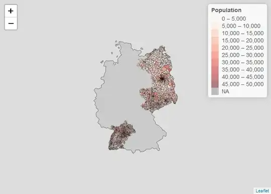
GER_postcode@data$einwohner2 <- ifelse(substr(GER_postcode@data$plz, 1, 1) %in% c("0", "1", "7"), GER_postcode@data$einwohner, NA)
# Plot Subsample
library(leaflet)
qpal <- colorBin("Reds", GER_postcode@data$einwohner2, bins=10)
leaflet(GER_postcode) %>%
addPolygons(stroke = TRUE,opacity = 1,fillOpacity = 0.5, smoothFactor = 0.5,
color="black",fillColor = ~qpal(einwohner2),weight = 1) %>%
addLegend(values=~einwohner2,pal=qpal,title="Population")
How can I make the map show those postcode shapes with values and combine all other where the value is NA?

I was looking at library(rgeos) and gUnaryUnion() that units all units in a shapefile to outer borders. Although I only need to do this on a subset.