Ópusztaszer | |
|---|---|
Village | |
 Coat of arms | |
| Country | |
| County | Csongrád |
| District | Kistelek |
| Area | |
| • Total | 59.50 km2 (22.97 sq mi) |
| Population (2001) | |
| • Total | 2,290 |
| • Density | 38.5/km2 (100/sq mi) |
| Time zone | UTC+1 (CET) |
| • Summer (DST) | UTC+2 (CEST) |
| Postal code | 6767 |
| Area code | (+36) 62 |
Ópusztaszer (till 1974 Sövényháza) is a village in Csongrád county, in the Southern Great Plain region of southern Hungary. It is most known as the location of the Ópusztaszer National Heritage Park.
Geography
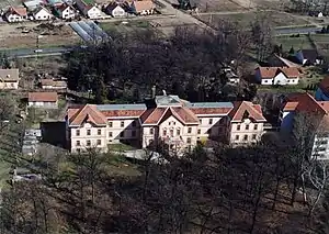
Ópusztaszer, palace from above
It covers an area of 59.5 km2 (23 sq mi) and has a population of 2,290 people (2001).
External links
Wikimedia Commons has media related to Ópusztaszer.
| Town (1) |
| |
|---|---|---|
| Villages (5) | ||
| Cities with county rights |
|   |
|---|---|---|
| Towns | ||
| Large villages | ||
| Villages |
| |
| Other topics |
| |
46°29′N 20°05′E / 46.483°N 20.083°E
This article is issued from Wikipedia. The text is licensed under Creative Commons - Attribution - Sharealike. Additional terms may apply for the media files.