Highway 20 | ||||
|---|---|---|---|---|
 | ||||
| Route information | ||||
| Maintained by Alberta Ministry of Transportation | ||||
| Length | 110.2 km[1] (68.5 mi) | |||
| Major junctions | ||||
| South end | ||||
| North end | ||||
| Location | ||||
| Country | Canada | |||
| Province | Alberta | |||
| Specialized and rural municipalities | Red Deer County, Lacombe County, Ponoka County, Wetaskiwin No. 10 County, Brazeau County | |||
| Towns | Sylvan Lake, Bentley, Rimbey | |||
| Villages | Breton | |||
| Highway system | ||||
|
| ||||
| ||||

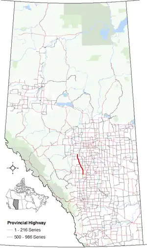
Alberta Provincial Highway No. 20, commonly referred to as Highway 20, is a highway in central Alberta, Canada, west of Highway 2.[2]
Route description

Highway 20 begins Highway 11 and travels north for 4 km (2 mi) along the east side of the town of Sylvan Lake to a roundabout with Highway 11A.[1] It continues for 16 km (10 mi) to Highway 12 in Bentley, passing the southeastern shore of Sylvan Lake at Jarvis Bay as well as the Jarvis Bay Provincial Park. It intersects Highway 771 2 km (1 mi) north of Bentley, which provides access to the west side of Gull Lake and Parkland Beach, and travels for 21 km (13 mi) in a northwesterly direction to Rimbey; Highway 20 bypasses Rimbey while Highway 20A is a business route through the town and connects with Highway 53 west. Highway 20 proceeds another 3 km (2 mi) before reconnecting with Highway 20A, and travels another 2 km (1 mi) to Highway 53 east, where it heads east towards Ponoka.[1]
Highway 20 continues north for 9 km (6 mi) to Bluffton where Highway 607 branches off to the west, another 13 km (8 mi) north to Hoadley where Highway 611 branches off to the east, and another 15 km (9 mi) north to Winfield where it crosses Highway 13. From Winfield, the highway continues north for 17 km (11 mi) to Breton where it crosses Highway 616 before it travels another 17 km (11 mi) north Alsike where it ends at Highway 39.[1][3]
History
Highway 20 was originally a short, 16 km (10 mi) long highway that ran from Highway 11 in Sylvan Lake to the Highway 12 / Highway 51 intersection in Bentley. From this intersection, Highway 12 continued north to Rimbey, Breton, and Alsike. In the mid-1980s, when Highway 11 was realigned to bypass Sylvan Lake, Highway 20 was extended 4 km (2 mi) to the south to connect with the new alignment. In January 1988, the 90 km (56 mi) section of Highway 12 between Bentley and Alsike was redesignated as Highway 20, while Highway 51 was decommissioned and redesignated as the new western section of Highway 12.[4]
Major intersections
From south to north:[5]
| Rural/specialized municipality | Location | km[1] | mi | Destinations | Notes |
|---|---|---|---|---|---|
| Red Deer County | Sylvan Lake | 0.0 | 0.0 | Traffic signals; proposed interchange and Hwy 781 realignment[6] | |
| 4.1 | 2.5 | Roundabout | |||
| ↑ / ↓ | Jarvis Bay | 7.3 | 4.5 | PAR 124 west – Jarvis Bay Provincial Park | |
| Lacombe County | | 10.7 | 6.6 | Aspelund Road – Blackfalds | |
| Bentley | 20.3 | 12.6 | Former Hwy 51 west; former northern terminus for Hwy 20 | ||
| | 22.3 | 13.9 | |||
| Ponoka County | Rimbey | 42.8 | 26.6 | ||
| 45.4 | 28.2 | South end of Hwy 53 concurrency | |||
| | 47.0 | 29.2 | North end of Hwy 53 concurrency | ||
| 53.9 | 33.5 | ||||
| Bluffton | 56.1 | 34.9 | UAR 165 north | ||
| Hoadley | 69.2 | 43.0 | |||
| County of Wetaskiwin No. 10 | Winfield | 83.7 | 52.0 | ||
| Brazeau County | Breton | 100.7 | 62.6 | ||
| Alsike | 110.2 | 68.5 | |||
1.000 mi = 1.609 km; 1.000 km = 0.621 mi
| |||||
Highway 20A
Highway 20A | |
|---|---|
| Location | Rimbey |
| Length | 3.2 km[7] (2.0 mi) |
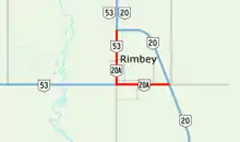
Alberta Provincial Highway No. 20A is the designation of a 3.2 km (2.0 mi) alternate route off Highway 20 serving the Town of Rimbey. It starts within Rimbey at Highway 53 and ends 1.6 km (1.0 mi) to the north at Highway 20.[2][7]
Major intersections
The entire route is in Ponoka County.
| Location | km[7] | mi | Destinations | Notes | |
|---|---|---|---|---|---|
| Rimbey | 0.0 | 0.0 | East entrance into Rimbey along 50 Avenue | ||
| 1.6 | 0.99 | Hwy 20A turns onto 51 St; south end of Hwy 53 concurrency | |||
| 3.2 | 2.0 | North entrance into Rimbey | |||
1.000 mi = 1.609 km; 1.000 km = 0.621 mi
| |||||
References
- 1 2 3 4 5 Google. "Highway 20 in Alberta" (Map). Google Maps. Google.
- 1 2 "Provincial Highway 1-216 Progress Chart" (PDF). Alberta Transportation. March 2015. Archived (PDF) from the original on April 10, 2016. Retrieved October 12, 2016.
- ↑ Alberta Official Road Map (Map) (2015 ed.). Alberta Tourism, Parks and Recreation. §§ J-5 and K-5.
- ↑ "Highway Numbers New". Red Deer Advocate. January 5, 1988. p. 12. Retrieved December 18, 2019 – via Newspapers.com.

- ↑ Alberta Road Atlas (2005 ed.). Oshawa, ON: MapArt Publishing Corp. p. 64.
- ↑ "Highway 11 Functional Planning Study - Executive Summary" (PDF). Government of Alberta. McElhanny Consulting Services Ltd. December 2013. Retrieved April 26, 2016.
- 1 2 3 Google. "Highway 20A in Rimbey, AB" (Map). Google Maps. Google.