Bazeilles-sur-Othain | |
|---|---|
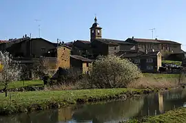 A general view of Bazeilles-sur-Othain | |
.svg.png.webp) Coat of arms | |
Location of Bazeilles-sur-Othain | |
 Bazeilles-sur-Othain 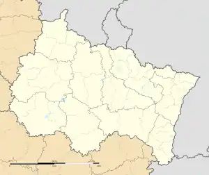 Bazeilles-sur-Othain | |
| Coordinates: 49°29′51″N 5°25′44″E / 49.4975°N 5.4289°E | |
| Country | France |
| Region | Grand Est |
| Department | Meuse |
| Arrondissement | Verdun |
| Canton | Montmédy |
| Intercommunality | Pays de Montmédy |
| Government | |
| • Mayor (2020–2026) | Fabienne Thomas[1] |
| Area 1 | 7.66 km2 (2.96 sq mi) |
| Population | 111 |
| • Density | 14/km2 (38/sq mi) |
| Time zone | UTC+01:00 (CET) |
| • Summer (DST) | UTC+02:00 (CEST) |
| INSEE/Postal code | 55034 /55600 |
| Elevation | 187–337 m (614–1,106 ft) (avg. 240 m or 790 ft) |
| 1 French Land Register data, which excludes lakes, ponds, glaciers > 1 km2 (0.386 sq mi or 247 acres) and river estuaries. | |
Bazeilles-sur-Othain (French pronunciation: [bazɛj syʁ ɔtɛ̃], literally Bazeilles on Othain) is a commune in the Meuse department in the Grand Est region in northeastern France.
Geography
The river Othain flows west through the southern part of the commune and crosses the village. The Chiers forms all of the commune's northern border.
Population
| Year | Pop. | ±% |
|---|---|---|
| 1962 | 118 | — |
| 1968 | 118 | +0.0% |
| 1975 | 109 | −7.6% |
| 1982 | 96 | −11.9% |
| 1990 | 72 | −25.0% |
| 1999 | 91 | +26.4% |
| 2007 | 96 | +5.5% |
| 2009 | 103 | +7.3% |
See also
References
- ↑ "Répertoire national des élus: les maires" (in French). data.gouv.fr, Plateforme ouverte des données publiques françaises. 13 September 2022.
- ↑ "Populations légales 2021". The National Institute of Statistics and Economic Studies. 28 December 2023.
Wikimedia Commons has media related to Bazeilles-sur-Othain.
This article is issued from Wikipedia. The text is licensed under Creative Commons - Attribution - Sharealike. Additional terms may apply for the media files.