Behshahr County
Persian: شهرستانِ بِهْشَهْر | |
|---|---|
County | |
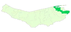 Location of Behshahr County in Mazandaran province | |
 Location of Mazandaran province in Iran | |
| Coordinates: 36°37′45″N 53°42′53″E / 36.62917°N 53.71472°E[1] | |
| Country | |
| Province | Mazandaran |
| Capital | Behshahr |
| Districts | Central, Yaneh Sar |
| Area | |
| • Total | 1,416.27 km2 (546.82 sq mi) |
| Population (2016)[3] | |
| • Total | 168,769 |
| • Density | 120/km2 (310/sq mi) |
| Time zone | UTC+3:30 (IRST) |
| Behshahr County can be found at GEOnet Names Server, at this link, by opening the Advanced Search box, entering "9207234" in the "Unique Feature Id" form, and clicking on "Search Database". | |


.jpg.webp)
.jpg.webp)
.jpg.webp)

Behshahr County (in Persian: شهرستانِ بِهْشَهْر, romanized: Šahrestan-e-Behšahr and in Mazanderani: بِهْشَهْرِ شهرسّون, romanized: Behšahr-e-Šahresun) is in Mazandaran province, Iran on the Caspian Sea. Its capital is the city of Behshahr.
At the 2006 census, the county's population was 154,957 in 40,432 households.[4] The following census in 2011 counted 155,247 people in 46,100 households.[5] At the 2016 census, the county's population was 168,769 in 55,140 households.[3]
Administrative divisions
The population history of Behshahr County's administrative divisions over three consecutive censuses is shown in the following table. The latest census shows two districts, five rural districts, and three cities.[3]
| Administrative Divisions | 2006[4] | 2011[5] | 2016[3] |
|---|---|---|---|
| Central District | 144,332 | 148,279 | 157,097 |
| Kuhestan RD | 17,420 | 16,680 | 17,436 |
| Miyan Kaleh RD | 18,320 | 17,355 | 18,469 |
| Panj Hezareh RD | 3,653 | 3,299 | 3,772 |
| Behshahr (city) | 83,537 | 89,251 | 94,702 |
| Khalil Shahr (city) | 10,096 | 10,141 | 11,032 |
| Rostamkola (city) | 11,306 | 11,553 | 11,686 |
| Yaneh Sar District | 10,625 | 6,968 | 11,672 |
| Ashrestaq RD | 7,284 | 4,433 | 6,911 |
| Shohada RD | 3,341 | 2,535 | 4,761 |
| Total | 154,957 | 155,247 | 168,769 |
See also
Wikimedia Commons has media related to Behshahr County.
References
- ↑ OpenStreetMap contributors (23 May 2023). "Behshahr County" (Map). OpenStreetMap. Retrieved 23 May 2023.
- ↑ Mozaffa F.; Aghae Y.; Taghvaei M.; Shaykh Baygloo R. (Winter 2011). "Analysis of Intraregional Disparities of Development in Mazandaran Ostan" (PDF). Geography and Environmental Planning. 40 (4): 13–28. Retrieved 23 August 2013.
- 1 2 3 4 "Census of the Islamic Republic of Iran, 1395 (2016)". AMAR (in Persian). The Statistical Center of Iran. p. 02. Archived from the original (Excel) on 7 October 2021. Retrieved 19 December 2022.
- 1 2 "Census of the Islamic Republic of Iran, 1385 (2006)". AMAR (in Persian). The Statistical Center of Iran. p. 02. Archived from the original (Excel) on 20 September 2011. Retrieved 25 September 2022.
- 1 2 "Census of the Islamic Republic of Iran, 1390 (2011)" (Excel). Iran Data Portal (in Persian). The Statistical Center of Iran. p. 02. Retrieved 19 December 2022.
| Capital | |||||||||||||||
|---|---|---|---|---|---|---|---|---|---|---|---|---|---|---|---|
| Districts |
| ||||||||||||||
This article is issued from Wikipedia. The text is licensed under Creative Commons - Attribution - Sharealike. Additional terms may apply for the media files.