| Elk Range | |
|---|---|
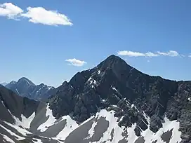 Mt. Tyrwhitt from Pocaterra Ridge | |
| Highest point | |
| Peak | Mount Pocaterra |
| Elevation | 2,941 m (9,649 ft)[1] |
| Coordinates | 50°35′57″N 115°01′44″W / 50.59917°N 115.02889°W[1] |
| Dimensions | |
| Area | 234 km2 (90 sq mi)[2] |
| Geography | |
 | |
| Country | Canada |
| Provinces | British Columbia and Alberta |
| Range coordinates | 50°31′09″N 114°57′14″W / 50.51917°N 114.95389°W[3] |
| Parent range | Front Ranges |
| Topo map | NTS 82J7 Mount Head[3] |
The Elk Range is a mountain range of the Canadian Rockies, located on the southern edge of Kananaskis on the Alberta-British Columbia border. The range was named for elk found on the mountain slopes and in the nearby Elk River valley. Originally known as the Elk Mountains in 1917, the name was formally changed to the Elk Range in 1951.[4]
This range includes the following mountains and peaks:
| Mountain/Peak | metres | feet |
|---|---|---|
| Mount Pocaterra | 2,941 | 9,650 |
| Mount McPhail | 2,883 | 9,459 |
| Mount Tyrwhitt | 2,874 | 9,430 |
| Mount Bishop | 2,850 | 9,350 |
| Mount Loomis | 2,822 | 9,259 |
| Mount Odlum | 2,716 | 8,911 |
| Horned Mountain | 2,667 | 8,750 |
References
- 1 2 "Mount Pocaterra". Bivouac.com. Retrieved 2021-07-17.
- ↑ "Elk Range". Bivouac.com. Retrieved 2021-07-17.
- 1 2 "Elk Range (Alberta)". Geographical Names Data Base. Natural Resources Canada. Retrieved 2021-07-17.
- ↑ "Elk Range". BC Geographical Names. Retrieved 2021-07-17.
This article is issued from Wikipedia. The text is licensed under Creative Commons - Attribution - Sharealike. Additional terms may apply for the media files.