Espinasse | |
|---|---|
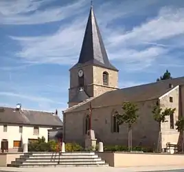 The church in Espinasse | |
Location of Espinasse | |
 Espinasse 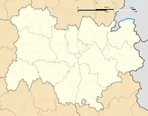 Espinasse | |
| Coordinates: 46°02′19″N 2°42′43″E / 46.0386°N 2.7119°E | |
| Country | France |
| Region | Auvergne-Rhône-Alpes |
| Department | Puy-de-Dôme |
| Arrondissement | Riom |
| Canton | Saint-Éloy-les-Mines |
| Intercommunality | CC Pays de Saint-Éloy |
| Government | |
| • Mayor (2020–2026) | Michel Bancarel[1] |
| Area 1 | 23.95 km2 (9.25 sq mi) |
| Population | 282 |
| • Density | 12/km2 (30/sq mi) |
| Time zone | UTC+01:00 (CET) |
| • Summer (DST) | UTC+02:00 (CEST) |
| INSEE/Postal code | 63152 /63390 |
| Elevation | 598–774 m (1,962–2,539 ft) (avg. 680 m or 2,230 ft) |
| Website | www.espinasse63.com |
| 1 French Land Register data, which excludes lakes, ponds, glaciers > 1 km2 (0.386 sq mi or 247 acres) and river estuaries. | |
Espinasse (French pronunciation: [ɛspinas]; Occitan: Espinassa) is a commune in the Puy-de-Dôme department in Auvergne in central France. Small farming village in the Pays of Combrailles, in the canton of Saint-Éloy-les-Mines, the village is nestled in a hollow, about nine kilometers west of the town of Saint-Gervais-d'Auvergne. The inhabitants of the commune are known as Espinassois or Espinassoises.[3]
During the Middle Ages and the Early modern period, the region of Combrailles was of paramount importance at territorial level because it was located at the crossroads of several lordships (Bourbonnais, Auvergne and Limousin). Therefore, the town of Espinasse suffered this proximity and was divided into fiefs belonging among others to the House of Le Loup, the House of Montmorency and the House of La Fayette.
Geography
Espinasse is located some 30 km west of Combronde and 23 km north-west of Bromont-Lamothe. Access to the commune is by the D 13 from Charensat in the south-west which passes through the commune and the village before continuing north to Pionsat. The D 62 comes from Saint-Priest-des-Champs in the south-east. The D 18 comes from Saint-Julien-la-Geneste in the north-east. The D 528 comes from Bussières in the north-west. The commune is mixed forest and farmland.[4]
Neighbouring communes and villages
Source:[5]
Places adjacent to Espinasse, Puy-de-Dôme | ||||||||||||||||
|---|---|---|---|---|---|---|---|---|---|---|---|---|---|---|---|---|
| ||||||||||||||||
Administration
_mairie.JPG.webp)
| From | To | Name |
|---|---|---|
| 1800 | 1808 | Gilbert Gory |
| 1808 | 1813 | Annet Lecuyer |
| 1813 | 1815 | Jean-Joseph Boutarel |
| 1815 | 1816 | Paul Sanne |
| 1816 | 1818 | Amable Nouhen |
| 1819 | 1830 | Charles Marien Baron |
| 1830 | 1840 | Claude Fribaud |
| 1840 | 1849 | Charles Marien Baron |
| 1849 | 1875 | Frédéric Gory |
| 1875 | 1877 | Marien Martin |
| 1877 | 1885 | Jean Chabry |
| 1885 | 1889 | Marien Lecuyer |
| 1889 | 1893 | François Carton |
| 1893 | 1895 | Gilbert Martin |
| 1895 | 1904 | Etienne Gory |
| 1904 | 1912 | Annet Charvillat |
| 1912 | 1944 | Eugène Charvillat |
| 1944 | 1959 | Michel Carte |
| 1959 | 1975 | Roger Laroche |
| 1975 | 2005 | François Gardet |
| 2005 | 2020 | Marc Gidel |
| 2020 | 2026 | Michel Bancarel |
Demography
In 2017 the commune had 294 inhabitants.
|
| ||||||||||||||||||||||||||||||||||||||||||||||||||||||||||||||||||||||||||||||||||||||||||||||||||||||||||||||||||
| Source: EHESS[7] and INSEE[8] | |||||||||||||||||||||||||||||||||||||||||||||||||||||||||||||||||||||||||||||||||||||||||||||||||||||||||||||||||||
Culture and heritage
Cultural events and festivities
The Hay Fest (La Fête des Foins in French) is the main festival in the village since 1998. It takes place in July.
Tourist monuments and places
- The Church of St. Martin, very old, is partly Romanesque but was changed to the 2nd Gothic era. A statuary element painted white stone shows St. Margaret of Antioch slaying the dragon. It dates from the fifteenth century. Saint Martin is the patron of the parish but is also under the protection of Saint Gal, second patron.
- The local school, completed in 1900, was also a town hall. The building was called Mairie-École at the time.
- The Résistance site at Cacherat - Camp Gabriel Peri - which received on 23 October 1943, one of the two groups of escapees from the prison of Le Puy-en-Velay.
- The Château of Pierrebrune, dating from the thirteenth century, rebuilt to modern, was the residence of the lords of Espinasse. In June 1440 during the Praguerie, King Charles VII, who came from Auzances and went to Montaigut-en-Combraille, passed through Pierrebrune.
- The War Memorial in front of the church.
_%C3%A9cole.JPG.webp) The local school
The local school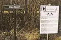 The Resistance site at Cacherat
_monument_aux_morts.JPG.webp) The War Memorial
The War Memorial_%C3%A9glise_(01).JPG.webp) The Church of St. Martin
The Church of St. Martin
See also
References
- ↑ "Répertoire national des élus: les maires". data.gouv.fr, Plateforme ouverte des données publiques françaises (in French). 2 December 2020.
- ↑ "Populations légales 2021". The National Institute of Statistics and Economic Studies. 28 December 2023.
- ↑ Inhabitants of Puy-de-Dôme (in French)
- ↑ Google Maps
- ↑ Géoportail, IGN (in French)
- ↑ List of Mayors of Espinasse (in French)
- ↑ Des villages de Cassini aux communes d'aujourd'hui: Commune data sheet Espinasse, EHESS (in French).
- ↑ Population en historique depuis 1968, INSEE
External links
- Espinasse website (in French)