Ghiasabad
Persian: غياثآباد | |
|---|---|
Village | |
 Ghiasabad | |
| Coordinates: 34°24′55″N 49°36′28″E / 34.41528°N 49.60778°E[1] | |
| Country | |
| Province | Markazi |
| County | Farahan |
| District | Central |
| Rural District | Farmahin |
| Population (2016)[2] | |
| • Total | 1,231 |
| Time zone | UTC+3:30 (IRST) |
Ghiasabad (Persian: غياثآباد, also Romanized as Ghīās̄ābād and Gheyāsābād)[3] is a village in Farmahin Rural District of the Central District of Farahan County, Markazi province, Iran.
At the 2006 National Census, its population was 1,333 in 364 households, when it was in the former Farahan District of Tafresh County.[4] The following census in 2011 counted 1,344 people in 426 households, by which time the district had been separated from the county in the establishment of Farahan County.[5] The latest census in 2016 showed a population of 1,231 people in 392 households. It was the largest village in its rural district.[2]
References
- ↑ OpenStreetMap contributors (30 August 2023). "Ghiasabad, Farahan County" (Map). OpenStreetMap. Retrieved 30 August 2023.
- 1 2 "Census of the Islamic Republic of Iran, 1395 (2016)". AMAR (in Persian). The Statistical Center of Iran. p. 00. Archived from the original (Excel) on 17 October 2020. Retrieved 19 December 2022.
- ↑ Ghiasabad can be found at GEOnet Names Server, at this link, by opening the Advanced Search box, entering "-3064273" in the "Unique Feature Id" form, and clicking on "Search Database".
- ↑ "Census of the Islamic Republic of Iran, 1385 (2006)". AMAR (in Persian). The Statistical Center of Iran. p. 00. Archived from the original (Excel) on 20 September 2011. Retrieved 25 September 2022.
- ↑ "Census of the Islamic Republic of Iran, 1390 (2011)" (Excel). Iran Data Portal (in Persian). The Statistical Center of Iran. p. 00. Retrieved 19 December 2022.
Markazi Province, Iran | |||||||||||||||||||||||||
|---|---|---|---|---|---|---|---|---|---|---|---|---|---|---|---|---|---|---|---|---|---|---|---|---|---|
| Capital | 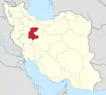 | ||||||||||||||||||||||||
| Counties and cities |
| ||||||||||||||||||||||||
| Sights |
| ||||||||||||||||||||||||
| populated places | |||||||||||||||||||||||||
This article is issued from Wikipedia. The text is licensed under Creative Commons - Attribution - Sharealike. Additional terms may apply for the media files.