Kalaleh County
Persian: شهرستان کلاله | |
|---|---|
County | |
 Rugged landscape in Kalaleh County | |
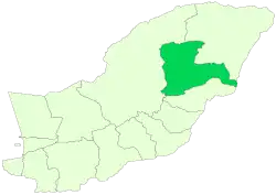 Location of Kalaleh County in Golestan province | |
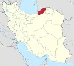 Location of Golestan province in Iran | |
| Coordinates: 37°34′N 55°41′E / 37.567°N 55.683°E[1] | |
| Country | |
| Province | Golestan |
| Capital | Kalaleh |
| Districts | Central, Pishkamar |
| Population (2016)[2] | |
| • Total | 117,319 |
| Time zone | UTC+3:30 (IRST) |
| Kalaleh County at GEOnet Names Server | |
Kalaleh County (Persian: شهرستان کلاله) is in Golestan province, Iran. Its capital is the city of Kalaleh. At the 2006 census, the county's population was 149,857 in 31,475 households.[3] The following census in 2011 counted 110,473 people in 28,483 households, by which time the former Maraveh Tappeh District had been separated from the county to form Maraveh Tappeh County.[4] At the 2016 census, the county's population was 117,319 in 32,998 households.[2]
Administrative divisions
The population history and structural changes of Kalaleh County's administrative divisions over three consecutive censuses are shown in the following table. The latest census shows two districts, five rural districts, and two cities.[2]
After the 2016 census, Zavkuh Rural District was separated from the Central District in the establishment of Pishkamar District, and Maraveh Tappeh District was separated from the county in the establishment of Maraveh Tappeh County.[5]
| Administrative Divisions | 2006[3] | 2011[4] | 2016[2] |
|---|---|---|---|
| Central District | 103,983 | 84,064 | 90,342 |
| Aq Su RD | 14,972 | 17,342 | 13,166 |
| Kongur RD | 21,115 | 22,371 | 23,168 |
| Tamran RD | 16,625 | 16,400 | 17,832 |
| Zavkuh RD | 23,610 | ||
| Kalaleh (city) | 27,661 | 27,951 | 36,176 |
| Maraveh Tappeh District1 | 45,874 | ||
| Golidagh RD | 16,506 | ||
| Maraveh Tappeh RD | 23,766 | ||
| Maraveh Tappeh (city) | 5,602 | ||
| Pishkamar District | 26,409 | 26,977 | |
| Arab Dagh RD | 14,644 | 14,803 | |
| Zavkuh RD | 11,765 | 6,397 | |
| Faraghi (city)2 | 5,777 | ||
| Total | 149,857 | 110,473 | 117,319 |
| RD: Rural District 1Became a part of Maraveh Tappeh County[5] 2Formerly the village of Pishkamar[6] | |||
References
- ↑ OpenStreetMap contributors (13 October 2023). "Kalaleh County" (Map). OpenStreetMap. Retrieved 13 October 2023.
- 1 2 3 4 "Census of the Islamic Republic of Iran, 1395 (2016)". AMAR (in Persian). The Statistical Center of Iran. p. 27. Archived from the original (Excel) on 29 March 2019. Retrieved 19 December 2022.
- 1 2 "Census of the Islamic Republic of Iran, 1385 (2006)". AMAR (in Persian). The Statistical Center of Iran. p. 27. Archived from the original (Excel) on 20 September 2011. Retrieved 25 September 2022.
- 1 2 "Census of the Islamic Republic of Iran, 1390 (2011)" (Excel). Iran Data Portal (in Persian). The Statistical Center of Iran. p. 27. Retrieved 19 December 2022.
- 1 2 Davodi, Parviz (18 September 2016). "Letter of approval regarding the reforms of country divisions in Golestan province". Research Center of the System of Laws of the Islamic Council of the Farabi Library (in Persian). Ministry of Interior, Political-Defense Commission. Archived from the original on 23 November 2013. Retrieved 19 November 2023.
- ↑ "Sunni emam of Faraghi city was introduced". Tasnim News (in Persian). Tasnim News Agency. 13 February 2014. Archived from the original on 13 October 2023. Retrieved 13 October 2023.
Golestan Province, Iran | ||
|---|---|---|
| Capital |  | |
| Counties and cities | ||
| Sights |
| |
| populated places | ||