Kalyanmal
Kalyānmal Rathauli | |
|---|---|
Populated place | |
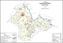 Map showing Kalyanmal (#839) in Kothwan CD block | |
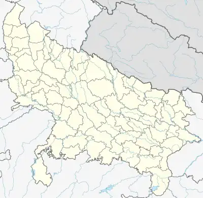 Kalyanmal Location in Uttar Pradesh, India  Kalyanmal Kalyanmal (India) | |
| Coordinates: 27°14′07″N 80°32′06″E / 27.235382°N 80.534914°E[1] | |
| Country | |
| State | Uttar Pradesh |
| District | Hardoi |
| Area | |
| • Total | 11.642 km2 (4.495 sq mi) |
| Population (2011)[2] | |
| • Total | 8,295 |
| • Density | 710/km2 (1,800/sq mi) |
| Languages | |
| • Official | Hindi |
| Time zone | UTC+5:30 (IST) |
Kalyanmal is a village in Kothwan block of Hardoi district, Uttar Pradesh, India.[2] Historically the seat of a pargana,[3] Kalyanmal is located 11 km from the city of Beniganj,[4] on the north side of the road leading to Atrauli and Bhatpurwaghat.[3] Also close by is the road running from Sandila to Gundlamau in Sitapur district.[3] Every Sunday during the month of Bhadon, a fair is held at Hattia Haran, a tank south of Kalyanmal where the god Rama is said to have bathed.[3] Kalyanmal also hosts a small fair to Panchabgir Mahadeo during the month of Aghan.[3] As of 2011, the population of Kalyanmal is 8,295, in 1,532 households.[2]
History
According to legend, Kalyanmal was originally called Rathauli, because Ramachandra's chariot had stopped here on the way back from Sri Lanka.[3] A mile to the south of Kalyanmal is a pool called Hattia Haran, which is where Ramachandra is said to have bathed.[3] Another tradition associated with Kalyanmal is found at the temple to Panchabgir Mahadeo: although the structure itself is modern, the lingam is much older and was supposedly set up by Judhisthir, the raja of Hastinapura.[3]
Apart from these legends, the earliest record of Kalyanmal's history is the traditional account of its conquest by the Bais raja Kumar, sometime before 1400.[3] Kumar drove out the previous Thathera rulers and built a fort at Rathauli, which became his capital.[3] The ruins of this fort still exist and are now called Wairi Dih.[3] However, the Sikarwar raja Nag Mal later murdered Kumar and seized his lands.[3] The modern town of Kalyanmal was supposedly then founded by Nag Mal's grandson, Kalyan Sah.[3]
Kalyanmal became the seat of a pargana during the reign of Aurangzeb.[3] A fort was built here at that time, and a garrison was posted along with one cannon.[3]
In 1901, the population of Kalyanmal was 1,783, with almost all the locals belonging to the Chamar community.[3] There was a village school at the time, and the average attendance at the Hattia Haran fair was about 5,000 people.[3]
The 1961 census recorded Kalyanmal as comprising 17 hamlets, with a total population of 3,393 people (1,805 male and 1,588 female) in 618 households and 498 physical houses.[5] The area of the village was given as 2,938 acres.[4]
The 1981 census recorded Kalyanmal as having a population of 5,075, in 1,092 households, and covering an area of 1,190.63 hectares.[4]
References
- ↑ "Geographic Names Search WebApp". Search for "Kalyanmal" here.
- 1 2 3 4 "Census of India 2011: Uttar Pradesh District Census Handbook - Hardoi, Part A (Village and Town Directory)" (PDF). Census 2011 India. pp. 389–406. Retrieved 14 June 2021.
- 1 2 3 4 5 6 7 8 9 10 11 12 13 14 15 16 17 Nevill, H.R. (1904). Hardoi - A Gazetteer. Allahabad: Government Press. pp. 208–11. Retrieved 14 June 2021.
- 1 2 3 Census 1981 Uttar Pradesh: District Census Handbook Part XIII-A: Village & Town Directory, District Hardoi (PDF). 1982. pp. 238–9. Retrieved 14 June 2021.
- ↑ Census 1961: District Census Handbook, Uttar Pradesh (36 - Hardoi District) (PDF). Lucknow. 1965. pp. 146, cxxvi-cxxvii of section "Sandila Tahsil". Retrieved 14 June 2021.
{{cite book}}: CS1 maint: location missing publisher (link)