Labelle | |
|---|---|
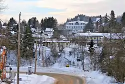 Downtown Labelle | |
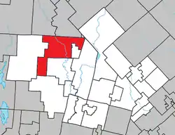 Location within Les Laurentides RCM | |
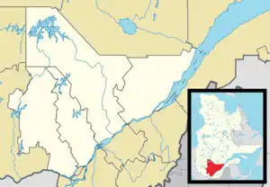 Labelle Location in central Quebec | |
| Coordinates: 46°17′N 74°44′W / 46.283°N 74.733°W[1] | |
| Country | Canada |
| Province | Quebec |
| Region | Laurentides |
| RCM | Les Laurentides |
| Constituted | January 27, 1973 |
| Government | |
| • Mayor | Gilbert Brassard |
| • Federal riding | Laurentides—Labelle |
| • Prov. riding | Labelle |
| Area | |
| • Total | 216.30 km2 (83.51 sq mi) |
| • Land | 196.69 km2 (75.94 sq mi) |
| Population (2021)[3] | |
| • Total | 2,765 |
| • Density | 12.3/km2 (32/sq mi) |
| • Pop 2016-2021 | |
| • Dwellings | 2,017 |
| Time zone | UTC−5 (EST) |
| • Summer (DST) | UTC−4 (EDT) |
| Postal code(s) | |
| Area code | 819 |
| Highways | |
| Website | www.municipalite .labelle.qc.ca |
Labelle is a village and municipality in the Laurentides region of Quebec, Canada, part of the Les Laurentides Regional County Municipality. Its large L-shaped territory surrounds Lake Labelle, and the village is located along the Rouge River and Route 117.
Demographics
Population trend:[4]
- Population in 2021: 2765 (2016 to 2021 population change: 11.6%)
- Population in 2016: 2477
- Population in 2011: 2445
- Population in 2006: 2258
- Population in 2001: 2272
- Population in 1996: 2256 (or 2271 when adjusted for 2001 boundaries)
- Population in 1991: 2090
Private dwellings occupied by usual residents: 1362 (total dwellings: 2017)
Mother tongue:
- English as first language: 2.6%
- French as first language: 94.6%
- English and French as first language: 0.9%
- Other as first language: 1.5%
Education
Sainte Agathe Academy (of the Sir Wilfrid Laurier School Board) in Sainte-Agathe-des-Monts serves English-speaking students in this community for both elementary and secondary levels.[5]
References
- ↑ "Banque de noms de lieux du Québec: Reference number 32796". toponymie.gouv.qc.ca (in French). Commission de toponymie du Québec.
- 1 2 "Répertoire des municipalités: Geographic code 78120". www.mamh.gouv.qc.ca (in French). Ministère des Affaires municipales et de l'Habitation.
- 1 2 "Profile table, Census Profile, 2021 Census of Population - Labelle, Municipalité (MÉ) [Census subdivision], Quebec". 9 February 2022.
- ↑ Statistics Canada: 1996, 2001, 2006, 2011, 2016, 2021 census
- ↑ "About Us." Saint Agathe Academy. Retrieved on September 4, 2017. See Elementary zone map Archived 2017-09-04 at the Wayback Machine and Secondary zone map Archived 2017-09-04 at the Wayback Machine - Note that all areas covered in the elementary map are also covered in the secondary one.
External links
 Media related to Labelle, Quebec at Wikimedia Commons
Places adjacent to Labelle, Quebec | ||||||||||||||||
|---|---|---|---|---|---|---|---|---|---|---|---|---|---|---|---|---|
| ||||||||||||||||
| Cities/towns | |
|---|---|
| Municipalities | |
| Townships | |
| Villages | |
| |
This article is issued from Wikipedia. The text is licensed under Creative Commons - Attribution - Sharealike. Additional terms may apply for the media files.