Laurelton, Pennsylvania | |
|---|---|
| Country | United States |
| State | Pennsylvania |
| County | Union |
| Township | Hartley |
| Area | |
| • Total | 0.57 sq mi (1.48 km2) |
| • Land | 0.57 sq mi (1.48 km2) |
| • Water | 0.00 sq mi (0.00 km2) |
| Population | |
| • Total | 217 |
| • Density | 380.70/sq mi (146.89/km2) |
| Time zone | UTC-5 (Eastern (EST)) |
| • Summer (DST) | UTC-4 (EDT) |
| FIPS code | 42-41856 |
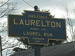
Laurelton is a census-designated place[3] located in Hartley Township, Union County in the state of Pennsylvania. It is located in western Union County along Pennsylvania Route 235. As of the 2010 census[4] the population was 221 residents.
Demographics
| Census | Pop. | Note | %± |
|---|---|---|---|
| 2020 | 217 | — | |
| U.S. Decennial Census[5] | |||
References
- ↑ "ArcGIS REST Services Directory". United States Census Bureau. Retrieved October 12, 2022.
- ↑ "Census Population API". United States Census Bureau. Retrieved October 12, 2022.
- ↑ 2010 Census Interactive Population Search: PA - Laurelton CDP
- ↑ US Census Bureau
- ↑ "Census of Population and Housing". Census.gov. Retrieved June 4, 2016.
Municipalities and communities of Union County, Pennsylvania, United States | ||
|---|---|---|
| Boroughs | 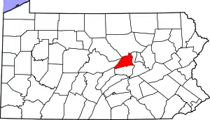 | |
| Townships | ||
| CDPs | ||
| Unincorporated communities | ||
This article is issued from Wikipedia. The text is licensed under Creative Commons - Attribution - Sharealike. Additional terms may apply for the media files.