Marybank | |
|---|---|
Suburb | |
 | |
| Coordinates: 41°13′40″S 173°19′20″E / 41.22778°S 173.32222°E | |
| Country | New Zealand |
| Region | Nelson |
| Ward |
|
| Electorates | |
| Government | |
| • Territorial Authority | Nelson City Council |
| • Mayor of Nelson | Nick Smith |
| • Nelson MP | Rachel Boyack |
| • Te Tai Tonga MP | Tākuta Ferris |
| Area | |
| • Total | 1.01 km2 (0.39 sq mi) |
| • Land | 1.01 km2 (0.39 sq mi) |
| • Water | 0 km2 (0 sq mi) |
| Population (June 2023)[2] | |
| • Total | 1,100 |
| • Density | 1,100/km2 (2,800/sq mi) |
| Time zone | UTC+12 (NZST) |
| • Summer (DST) | UTC+13 (NZDT) |
| Postcode | 7010 |
| Area code | 03 |
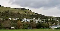
Marybank is a suburb of Nelson, New Zealand. It lies on State Highway 6 close to the northern end of Nelson Haven, between Atawhai and Wakapuaka.[3][4]
Marybank Reserve is the settlement's local park.[5]
The Boulder Bank, a rare rocky bank located offshore of Marybank, is accessible from just north of the settlement. It is managed by the Department of Conservation.[6]
History
The estimated population of Marybank was 960 in 1996.[7]
It reached 970 in 2001, 930 in 2006, 1,800 in 2013, and 1,950 in 2018.[7]
Demography
The Marybank statistical area covers 1.01 km2 (0.39 sq mi).[1] It had an estimated population of 1,100 as of June 2023,[2] with a population density of 1,089 people per km2.
| Year | Pop. | ±% p.a. |
|---|---|---|
| 2006 | 906 | — |
| 2013 | 1,011 | +1.58% |
| 2018 | 1,068 | +1.10% |
| Source: [8] | ||
Marybank had a population of 1,068 at the 2018 New Zealand census, an increase of 57 people (5.6%) since the 2013 census, and an increase of 162 people (17.9%) since the 2006 census. There were 444 households, comprising 504 males and 567 females, giving a sex ratio of 0.89 males per female. The median age was 50.8 years (compared with 37.4 years nationally), with 168 people (15.7%) aged under 15 years, 111 (10.4%) aged 15 to 29, 519 (48.6%) aged 30 to 64, and 267 (25.0%) aged 65 or older.
Ethnicities were 94.7% European/Pākehā, 5.9% Māori, 0.8% Pasifika, 3.7% Asian, and 2.0% other ethnicities. People may identify with more than one ethnicity.
The percentage of people born overseas was 24.7, compared with 27.1% nationally.
Although some people chose not to answer the census's question about religious affiliation, 55.9% had no religion, 32.9% were Christian, 0.3% had Māori religious beliefs, 0.3% were Hindu, 0.3% were Muslim and 1.7% had other religions.
Of those at least 15 years old, 237 (26.3%) people had a bachelor's or higher degree, and 123 (13.7%) people had no formal qualifications. The median income was $34,800, compared with $31,800 nationally. 174 people (19.3%) earned over $70,000 compared to 17.2% nationally. The employment status of those at least 15 was that 387 (43.0%) people were employed full-time, 165 (18.3%) were part-time, and 30 (3.3%) were unemployed.[8]
Economy
In 2018, 9.2% of people worked in manufacturing, 9.2% worked in construction, 4.9% worked in hospitality, 3.8% worked in transport, 0.0% worked in finance and administration, 9.8% worked in education, and 9.2% worked in healthcare.[7]
Transport
As of 2018, among those who commute to work, 69.6% drove a car, 4.3% rode in a car, 4.3% use a bike, and 4.3% walk or run.[7]
Education
Clifton Terrace School is a co-educational state primary school for Year 1 to 6 students.[9] It has a roll of 270 as of April 2023.[10]
References
- 1 2 "ArcGIS Web Application". statsnz.maps.arcgis.com. Retrieved 31 July 2021.
- 1 2 "Population estimate tables - NZ.Stat". Statistics New Zealand. Retrieved 25 October 2023.
- ↑ Reed New Zealand atlas (2004) Auckland: Reed Publishing. Map 59. ISBN 0 7900 0952 8
- ↑ Wise's Nelson-Blenheim "Easyread" Map ISBN 1 877402 50 8
- ↑ "Nelson Parks and Reserves". gdc.govt.nz. Gisborne District Council.
- ↑ "DOC Places to Go – Nelson-Tasman". doc.govt.nz. Department of Conservation.
- 1 2 3 4 "Place Summary – Marybank". Stats NZ. Statistics New Zealand.
- 1 2 "Statistical area 1 dataset for 2018 Census". Statistics New Zealand. March 2020. Marybank (303800). 2018 Census place summary: Marybank
- ↑ "Clifton Terrace School Education Review Office Report". ero.govt.nz. Education Review Office.
- ↑ "Clifton Terrace School Ministry of Education School Profile". educationcounts.govt.nz. Ministry of Education.