Mrač | |
|---|---|
 View from the east | |
 Flag  Coat of arms | |
 Mrač Location in the Czech Republic | |
| Coordinates: 49°49′47″N 14°41′26″E / 49.82972°N 14.69056°E | |
| Country | |
| Region | Central Bohemian |
| District | Benešov |
| First mentioned | 1318 |
| Area | |
| • Total | 6.15 km2 (2.37 sq mi) |
| Elevation | 331 m (1,086 ft) |
| Population (2023-01-01)[1] | |
| • Total | 852 |
| • Density | 140/km2 (360/sq mi) |
| Time zone | UTC+1 (CET) |
| • Summer (DST) | UTC+2 (CEST) |
| Postal code | 257 21 |
| Website | www |
Mrač is a municipality and village in Benešov District in the Central Bohemian Region of the Czech Republic. It has about 900 inhabitants.
Geography
Mrač is located about 5 kilometres (3 mi) north of Benešov and 26 km (16 mi) southeast of Prague. It lies in the Benešov Uplands. The highest point is the hill V Hrobech at 410 m (1,350 ft) above sea level, located on the southern municipal border. The Benešovský Stream flows through the municipality.
History
The first written mention of Mrač is from 1318. The owners changed often and included various lesser nobles. In 1727, Mrač was sold to Count Jan Josef of Vrtba, who annexed it to the Konopiště estate.[2]
Transport
The I/3 road (part of the European route E55) passes through the municipality.
Mrač is located on the Prague–Benešov railway line.
Sights
The only cultural monument in Mrač is the Mrač Fortress. It is a complex of three buildings that consists of a stronghold from the 13th century, a brick fortress from the end of the 14th century, and the remains of a castle.[3]
Gallery
_(2).jpg.webp) Benešovský Stream in Mrač
Benešovský Stream in Mrač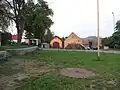 Centre of Mrač
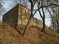 Mrač Fortress
References
- ↑ "Population of Municipalities – 1 January 2023". Czech Statistical Office. 2023-05-23.
- ↑ "Historie" (in Czech). Obec Mrač. Retrieved 2023-06-09.
- ↑ "Tvrz a archeologické stopy" (in Czech). National Heritage Institute. Retrieved 2023-06-09.