| Mulgrave Queensland | |||||||||||||||
|---|---|---|---|---|---|---|---|---|---|---|---|---|---|---|---|
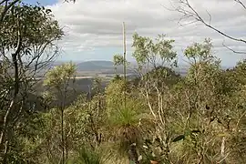 View from Mount Dalrymple, 2011 | |||||||||||||||
 Mulgrave | |||||||||||||||
| Coordinates | 19°57′16″S 147°02′02″E / 19.9544°S 147.0338°E | ||||||||||||||
| Population | 19 (SAL 2021)[1] | ||||||||||||||
| Postcode(s) | 4807 | ||||||||||||||
| Area | 819.8 km2 (316.5 sq mi) | ||||||||||||||
| Time zone | AEST (UTC+10:00) | ||||||||||||||
| Location |
| ||||||||||||||
| LGA(s) | Shire of Burdekin | ||||||||||||||
| State electorate(s) | Burdekin | ||||||||||||||
| Federal division(s) | Kennedy | ||||||||||||||
| |||||||||||||||
Mulgrave is a rural locality in the Shire of Burdekin, Queensland, Australia.[2] In the 2021 census, Mulgrave had a population of 19 people.[3]
Geography
Although the Shire of Burdekin is mostly lower-lying land used for growing sugarcane, Mulgrave in the south-west of the shire has more mountainous terrain, with a number of named peaks and gorges (from north to south):
- Woodhouse Mountain (19°50′15″S 147°07′52″E / 19.8376°S 147.1312°E) 155 metres (509 ft)[4][5]
- Bunkers Hill (19°55′48″S 146°56′03″E / 19.9300°S 146.9343°E) 430 metres (1,410 ft)[4][6]
- Nanny Goat Gorge (19°56′01″S 146°54′59″E / 19.9336°S 146.9163°E)[4]
- Mount Dalrymple (19°56′16″S 147°10′06″E / 19.9379°S 147.1683°E) 580 metres (1,900 ft)[4][7]
- Bird Gorge (19°57′40″S 146°55′34″E / 19.9611°S 146.9260°E)[4]
- Mount Benjonney (19°57′57″S 147°04′50″E / 19.9659°S 147.0806°E) 442 metres (1,450 ft)[4][8]
- Blue Mountain (20°00′22″S 146°54′48″E / 20.0062°S 146.9132°E) 616 metres (2,021 ft)[4][9]
There is some crop growing (including sugarcane) in the lower north-eastern part of the locality, but otherwise the predominant land use is grazing on native vegetation.[10]
History
The locality was officially named and bounded on 23 February 2001.[2]
Demographics
In the 2016 census, Mulgrave had a population of 21 people.[11]
In the 2021 census, Mulgrave had a population of 19 people.[3]
Education
There are no schools in Mulgrave. The nearest government primary schools are Clare State School in neighbouring Clare to the north-east and Millaroo State School in neighbouring Millaroo to the south-east. The nearest government secondary school is Home Hill State High School in Home Hill to the north-east. However, it is too distant from much of the locality for a daily commute and the options are distance education and boarding school.[12]
References
- ↑ Australian Bureau of Statistics (28 June 2022). "Mulgrave (Qld) (suburb and locality)". Australian Census 2021 QuickStats. Retrieved 28 June 2022.
- 1 2 "Mulgrave – locality in Shire of Burdekin (entry 42298)". Queensland Place Names. Queensland Government. Retrieved 18 November 2018.
- 1 2 Australian Bureau of Statistics (28 June 2022). "Mulgrave (SAL)". 2021 Census QuickStats. Retrieved 28 February 2023.
- 1 2 3 4 5 6 7 "Mountain peaks and capes - Queensland". Queensland Open Data. Queensland Government. 12 November 2020. Archived from the original on 25 November 2020. Retrieved 25 November 2020.
- ↑ "Woodhouse Mountain – mountain in Burdekin Shire (entry 37978)". Queensland Place Names. Queensland Government. Retrieved 25 November 2020.
- ↑ "Bunkers Hill – mountain in Burdekin Shire (entry 5291)". Queensland Place Names. Queensland Government. Retrieved 25 November 2020.
- ↑ "Mount Dalrymple – mountain in Burdekin Shire (entry 9251)". Queensland Place Names. Queensland Government. Retrieved 25 November 2020.
- ↑ "Mount Benjonney – mountain in Burdekin Shire (entry 2310)". Queensland Place Names. Queensland Government. Retrieved 25 November 2020.
- ↑ "Blue Mountain – mountain in Burdekin Shire (entry 3273)". Queensland Place Names. Queensland Government. Retrieved 25 November 2020.
- ↑ "Queensland Globe". State of Queensland. Retrieved 18 December 2023.
- ↑ Australian Bureau of Statistics (27 June 2017). "Mulgrave (SSC)". 2016 Census QuickStats. Retrieved 20 October 2018.
- ↑ "Layers: Locality; Schools and school catchments". Queensland Globe. Queensland Government. Archived from the original on 19 December 2017. Retrieved 18 December 2023.