Narowlya District
| |
|---|---|
 Flag  Coat of arms | |
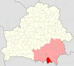 Location of Narowlya District within Gomel Region in Belarus | |
| Coordinates: 51°48′N 29°30′E / 51.800°N 29.500°E | |
| Country | Belarus |
| Region | Gomel Region |
| Administrative center | Narowlya |
| Area | |
| • Total | 1,588.82 km2 (613.45 sq mi) |
| Population (2023)[1] | |
| • Total | 10,494 |
| • Density | 6.6/km2 (17/sq mi) |
| Time zone | UTC+3 (MSK) |
| Website | Official website |
Narowlya District or Naroŭlia District[2] (Belarusian: Нараўлянскі раён, romanized: Naraulianski rajon; Russian: Наровлянский район) is a district (raion) of Gomel Region in Belarus. Its administrative center is the town of Narowlya.
Geography
The district includes the town of Narowlya, six rural councils (selsoviets), and several villages. Following the 1986 Chernobyl disaster, it is partially included in the Polesie State Radioecological Reserve.[3][4]
See also
References
- ↑ "Численность населения на 1 января 2023 г. и среднегодовая численность населения за 2022 год по Республике Беларусь в разрезе областей, районов, городов, поселков городского типа". belsat.gov.by. Archived from the original on 17 April 2023. Retrieved 5 August 2023.
- ↑ Official transliteration from Belarusian language (2007)
- ↑ Polesie Radio-ecological Zapovednik Archived 2016-07-31 at the Wayback Machine (APB BirdLife Belarus)
- ↑ 253459229 Polesie State Radioecological Reserve on OpenStreetMap
External links
![]() Media related to Narowlya District at Wikimedia Commons
Media related to Narowlya District at Wikimedia Commons
| Districts (raions) |  | |
|---|---|---|
| Cities and towns | ||
This article is issued from Wikipedia. The text is licensed under Creative Commons - Attribution - Sharealike. Additional terms may apply for the media files.