24°50′19″S 152°22′04″E / 24.838601°S 152.367884°E Paddy Island is an island (latitude 24° 50’ S X longitude 152° 22’E) [1] situated on the Burnett River, northeast of the city of Bundaberg in Queensland, Australia.
Etymology
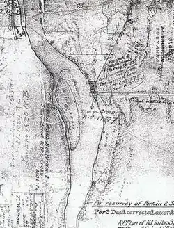
On a survey plan of the Burnett River transmitted to the Queensland Surveyor General on Tuesday 29 September 1868, the island was referenced as Coodes Island by the District Surveyor John Charlton Thompson (1827–1878).
Indigenous history
At Tirroan (later Gin Gin) Station [2] on Monday, June 4th, 1849, two young brothers, John and Peter Pegg, were out shepherding sheep when they were speared to death by local Taribelang clansmen.[2]
Gregory Blaxland Jr, the seventh and youngest son of the pioneer, farmer and explorer Gregory Blaxland (17 June 1778 – 1 January 1853), "organized a punitive party to deal with the savages", [2] which culminated in a bloody skirmish at the site of Gibson and Howes’ sugar plantation at ‘the Cedars’, south of Bundaberg.
"The blacks were shown no mercy, but (they) .. put up a mighty fight against the firearms of the whites, they of course having no better weapons than spears."[2]
Blaxland Jr was "regarded (by the Taribelang clansmen) as their chief enemy as all actions against the blacks was directed by him."[2]
When the opportunity for payback presented itself, Gregory Blaxland Jr. was ambushed, abducted, and violently clubbed to death at his pastoral station sometime in early August 1850.[2]
A retaliatory party "was organized among all (the) settlers and their employees, and they set out on their mission of revenge."[2]
Guided by a ‘friendly gin’, the "fugitive blacks were tracked down the Burnett River, where they had foregathered at a place now called (Waterview Station) Paddy's Island, not far from the mouth of the river."[2] Note. Coode's Island was still in existence in 1882. there is a marine chart available done by Cullen. this name disappears and soon after, Paddy's Island comes into existence and is referred to in 1878 unofficially. Paddy's was spawned from the results of dumping of dredge spoil. please refer to Votes and Proceeding documents. Paddy's Creek is named on the 1882 maritime chart of Cullen. page 5 of an 1868 river survey by Thompson that a Coode's Island did exist. plan W37.55 can be retrieved from the titles office. quite different to this representation. Rubyanna did not exist. again, refer to the sugar application files that are at the archives.
After the ensuing chaos, it is estimated that the death toll numbered in the hundreds.[2] Many were slaughtered whilst trying to cross from the west bank of the Burnett River to Paddy Island.[3]
Today, the custodianship of Paddy’s Island is a point of contention between neighbouring tribes and a number of traditional owners.[4]
References
- ↑ "Paddy Island (entry 25773)". Queensland Place Names. Queensland Government. Retrieved 28 August 2015.
- 1 2 3 4 5 6 7 8 9 EARLY GIN GIN and THE BLAXLAND TRAGEDY Archived 19 March 2012 at the Wayback Machine. library.uq.edu.au. (Read by ARTHUR LAURIE, a Vice-President of the Historical Society of Queensland at the meeting of the Society on 27 November 1952)
- ↑ Contributed (8 May 2014). "The ritual of remembering". news.griffith.edu.au. Retrieved 14 September 2023.
- ↑ Mike Derry (31 July 2010). "Island war as clan clashes | Bundaberg News | Local News in Bundaberg | Bundaberg News Mail". News-mail.com.au. Retrieved 27 June 2011.