Recanto das Emas | |
|---|---|
| Região Administrativa de Recanto das Emas Administrative Region of Recanto das Emas | |
Clockwise from top: Recanto das Emas sign; Greater rhea sculpture; Recanto das Emas bus terminal; S. Gabriel Arcanjo Chapel; Recanto das Emas viaduct; Unified Arts & Sports Center skatepark | |
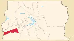 Localization of Recanto das Emas in Federal District | |
| Coordinates: 15°54′29″S 48°04′23″W / 15.90806°S 48.07306°W | |
| Country | |
| Region | Central-West |
| State | |
| Founded | July 28, 1993 |
| Government | |
| • Regional administrator | Paulo Roberto Amâncio da Silva[1] |
| Area | |
| • Total | 80.43 km2 (31.05 sq mi) |
| Population (2010)[2] | |
| • Total | 160,000 |
| Time zone | UTC−3 (BRT) |
| Postal Code (CEP) | 72600-000 |
| Area code | +55 61 |
| Website | www.recanto.df.gov.br |

.jpg.webp)


Recanto das Emas is an administrative region in the Federal District in Brazil. It is located to the westmost area of the Federal District, being bordered by Samambaia to the north, Riacho Fundo II to the east, Gama to the south, and the border to Goiás to the west.
See also
References
- ↑ "Perfil do administrador" (in Portuguese). Administração Regional de Recanto das Emas, DF. Retrieved 2015-01-01.
- ↑ "Pesquisa Distrital por Amostra de Domicílios - 2010/2011" (PDF) (in Portuguese). Codeplan. Retrieved 2014-05-27.
External links
Wikimedia Commons has media related to Recanto das Emas (Distrito Federal).

This article is issued from Wikipedia. The text is licensed under Creative Commons - Attribution - Sharealike. Additional terms may apply for the media files.