Twin Lakes | |
|---|---|
 Twin Lakes  Twin Lakes | |
| Coordinates: 38°9′56″N 119°19′36″W / 38.16556°N 119.32667°W | |
| Country | United States |
| State | California |
| County | Mono |
| Area | |
| • Total | 5.22 sq mi (13.52 km2) |
| • Land | 4.17 sq mi (10.80 km2) |
| • Water | 1.05 sq mi (2.72 km2) 0% |
| Elevation | 7,090 ft (2,160 m) |
| Population (2020)[3] | |
| • Total | 45 |
| • Density | 11/sq mi (4.2/km2) |
| Time zone | UTC-8 (Pacific (PST)) |
| • Summer (DST) | UTC-7 (PDT) |
| ZIP Code | 93517 (Bridgeport) |
| Area code(s) | 442/760 |
| FIPS code | 06-81048 |
| GNIS feature ID | 2804105[2] |
Twin Lakes is an unincorporated community and census-designated place (CDP) in Mono County, California, United States. It is located on the east side of the Sierra Nevada, encompassing the lakes of the same name and extending north down the outlet valley of Robinson Creek. The community of Mono Village is within the CDP. The area is part of Toiyabe National Forest and is 10 miles (16 km) southwest of Bridgeport. It was first listed as a CDP for the 2020 census, with a population of 45.[3]
References
- ↑ "2022 U.S. Gazetteer Files: California". United States Census Bureau. Retrieved November 8, 2022.
- 1 2 "Twin Lakes Census Designated Place". Geographic Names Information System. United States Geological Survey, United States Department of the Interior.
- 1 2 "P1. Race – Twin Lakes CDP (Mono County), California: 2020 DEC Redistricting Data (PL 94-171)". U.S. Census Bureau. Retrieved November 8, 2022.
Municipalities and communities of Mono County, California, United States | ||
|---|---|---|
| Town | 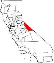 Mono County map | |
| CDPs | ||
| Unincorporated communities | ||
| Indian reservations | ||
| Former settlements | ||
This article is issued from Wikipedia. The text is licensed under Creative Commons - Attribution - Sharealike. Additional terms may apply for the media files.