Zarand County
Persian: شهرستان زرند | |
|---|---|
County | |
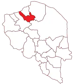 Location of Zarand County in Kerman province | |
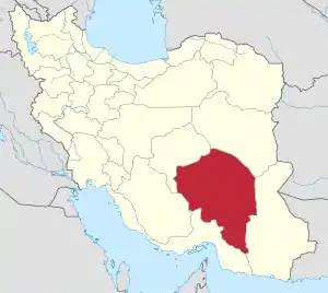 Location of Kerman province in Iran | |
| Coordinates: 30°57′N 56°21′E / 30.950°N 56.350°E[1] | |
| Country | |
| Province | Kerman |
| Capital | Zarand |
| Districts | Central, Yazdanabad |
| Population (2016)[2] | |
| • Total | 138,133 |
| Time zone | UTC+3:30 (IRST) |
| Zarand County can be found at GEOnet Names Server, at this link, by opening the Advanced Search box, entering "9206679" in the "Unique Feature Id" form, and clicking on "Search Database". | |
Zarand County (Persian: شهرستان زرند) is in Kerman province, Iran. Its capital is the city of Zarand.
At the 2006 census, the county's population was 119,144 in 28,746 households.[3] The following census in 2011 counted 129,104 people in 35,388 households, by which time Shaab Jereh Rural District had been separated from Kuhbanan County to join Zarand County.[4] At the 2016 census, the county's population was 138,133 in 39,451 households.[2]
Administrative divisions
The population history and structural changes of Zarand County's administrative divisions over three consecutive censuses are shown in the following table. The latest census shows two districts, 11 rural districts, and four cities.[2]
| Administrative Divisions | 2006[3] | 2011[4] | 2016[2] |
|---|---|---|---|
| Central District | 103,208 | 110,199 | 121,206 |
| Dasht-e Khak RD | 4,060 | 4,333 | 4,199 |
| Eslamabad RD | 830 | 837 | 1,136 |
| Hotkan RD | 1,247 | 679 | 898 |
| Jorjafak RD | 2,382 | 1,973 | 2,393 |
| Khanuk RD | 900 | 944 | 1,136 |
| Mohammadabad RD | 13,252 | 16,399 | 21,440 |
| Sarbanan RD | 2,817 | 2,263 | 2,706 |
| Vahdat RD | 15,033 | 18,078 | 19,720 |
| Khanuk (city) | 3,582 | 2,153 | 2,628 |
| Reyhan Shahr (city) | 4,360 | 4,791 | 4,580 |
| Zarand (city) | 54,745 | 57,749 | 60,370 |
| Yazdanabad District | 15,936 | 18,905 | 16,927 |
| Shaab Jereh RD1 | 1,790 | 2,383 | |
| Siriz RD | 4,792 | 5,048 | 4,841 |
| Yazdanabad RD | 6,107 | 6,625 | 4,096 |
| Siriz (city)2 | |||
| Yazdan Shahr (city) | 5,037 | 5,442 | 5,607 |
| Total | 119,144 | 129,104 | 138,133 |
| RD: Rural District 1Was a part of Kuhbanan County at the 2006 census 2Became a city after the 2016 census[5] | |||
Wikimedia Commons has media related to Zarand County.
References
- ↑ OpenStreetMap contributors (11 July 2023). "Zarand County" (Map). OpenStreetMap. Retrieved 11 July 2023.
- 1 2 3 4 "Census of the Islamic Republic of Iran, 1395 (2016)". AMAR (in Persian). The Statistical Center of Iran. p. 08. Archived from the original (Excel) on 20 October 2020. Retrieved 19 December 2022.
- 1 2 "Census of the Islamic Republic of Iran, 1385 (2006)". AMAR (in Persian). The Statistical Center of Iran. p. 08. Archived from the original (Excel) on 20 September 2011. Retrieved 25 September 2022.
- 1 2 "Census of the Islamic Republic of Iran, 1390 (2011)" (Excel). Iran Data Portal (in Persian). The Statistical Center of Iran. p. 08. Retrieved 19 December 2022.
- ↑ "The Council of Ministers agreed to turn Siriz village into a city". Young Journalists Club (in Persian). Ministry of Interior, Council of Ministers. 8 May 2019. Archived from the original on 11 July 2023. Retrieved 11 July 2023.
Kerman province, Iran | ||
|---|---|---|
| Capital | 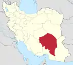 | |
| Counties and cities | ||
| Sights |
| |
| Places | ||
This article is issued from Wikipedia. The text is licensed under Creative Commons - Attribution - Sharealike. Additional terms may apply for the media files.