Bahramjerd
Persian: بهرام جرد | |
|---|---|
Village | |
 Bahramjerd | |
| Coordinates: 29°52′38″N 56°57′30″E / 29.87722°N 56.95833°E[1] | |
| Country | |
| Province | Kerman |
| County | Bardsir |
| District | Negar |
| Rural District | Negar |
| Population (2016)[2] | |
| • Total | 493 |
| Time zone | UTC+3:30 (IRST) |
Bahramjerd (Persian: بهرام جرد, also Romanized as Bahrāmjerd; also known as Bahrāmjird)[3] is a village in Negar Rural District of Negar District, Bardsir County, Kerman province, Iran.
At the 2006 National Census, its population was 219 in 70 households, when it was in the Central District of Bardsir County.[4] The following census in 2011 counted 272 people in 83 households, by which time the rural district had been separated from the district in the establishment of the new Negar District.[5] The latest census in 2016 showed a population of 493 people in 151 households. It was the largest village in its rural district.[2]
References
- ↑ OpenStreetMap contributors (27 June 2023). "Bahramjerd, Bardsir County" (Map). OpenStreetMap. Retrieved 27 June 2023.
- 1 2 "Census of the Islamic Republic of Iran, 1395 (2016)". AMAR (in Persian). The Statistical Center of Iran. p. 08. Archived from the original (Excel) on 20 October 2020. Retrieved 19 December 2022.
- ↑ Bahramjerd can be found at GEOnet Names Server, at this link, by opening the Advanced Search box, entering "-3054822" in the "Unique Feature Id" form, and clicking on "Search Database".
- ↑ "Census of the Islamic Republic of Iran, 1385 (2006)". AMAR (in Persian). The Statistical Center of Iran. p. 08. Archived from the original (Excel) on 20 September 2011. Retrieved 25 September 2022.
- ↑ "Census of the Islamic Republic of Iran, 1390 (2011)" (Excel). Iran Data Portal (in Persian). The Statistical Center of Iran. p. 08. Retrieved 19 December 2022.
Kerman province, Iran | ||
|---|---|---|
| Capital | 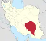 | |
| Counties and cities | ||
| Sights |
| |
| Places | ||
This article is issued from Wikipedia. The text is licensed under Creative Commons - Attribution - Sharealike. Additional terms may apply for the media files.