St. Anthony East | |
|---|---|
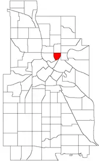 Location of St. Anthony East within the U.S. city of Minneapolis | |
| Country | United States |
| State | Minnesota |
| County | Hennepin |
| City | Minneapolis |
| Community | Northeast |
| Area | |
| • Total | 0.242 sq mi (0.63 km2) |
| Population (2020)[2] | |
| • Total | 2,161 |
| • Density | 8,900/sq mi (3,400/km2) |
| Time zone | UTC-6 (CST) |
| • Summer (DST) | UTC-5 (CDT) |
| ZIP code | 55413 |
| Area code | 612 |
| Census | Pop. | Note | %± |
|---|---|---|---|
| 1980 | 1,818 | — | |
| 1990 | 1,997 | 9.8% | |
| 2000 | 2,148 | 7.6% | |
| 2010 | 2,081 | −3.1% | |
| 2020 | 2,161 | 3.8% |
St. Anthony East is a neighborhood of the Northeast community in Minneapolis.
The neighborhood's boundaries are Broadway Street NE to the north, Central Avenue to the east and southeast, 2nd Avenue to the south, 5th Street NE to the southwest, and Washington Street to the west. 44°59′40″N 93°15′06″W / 44.9945°N 93.2517°W[3]
References
- ↑ "St. Anthony East neighborhood in Minneapolis, Minnesota (MN), 55413 detailed profile". City-Data. 2011. Retrieved 2013-11-16.
- ↑ "St. Anthony East neighborhood data". Minnesota Compass. Retrieved 2023-04-02.
- ↑ St. Anthony East, Minneapolis, MN. Google Earth. Retrieved 2011-03-09.
- St. Anthony East, Minneapolis, MN. Google Earth. Retrieved 2011-03-09.
External links
Places adjacent to St. Anthony East, Minneapolis | ||||||||||||||||
|---|---|---|---|---|---|---|---|---|---|---|---|---|---|---|---|---|
| ||||||||||||||||
This article is issued from Wikipedia. The text is licensed under Creative Commons - Attribution - Sharealike. Additional terms may apply for the media files.