Wandignies-Hamage | |
|---|---|
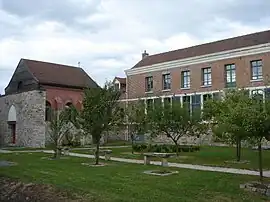 The Abbey of Hamage | |
_Nord-France.svg.png.webp) Coat of arms | |
Location of Wandignies-Hamage | |
 Wandignies-Hamage 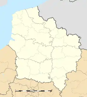 Wandignies-Hamage | |
| Coordinates: 50°24′01″N 3°18′55″E / 50.4003°N 3.3153°E | |
| Country | France |
| Region | Hauts-de-France |
| Department | Nord |
| Arrondissement | Douai |
| Canton | Sin-le-Noble |
| Intercommunality | Cœur d'Ostrevent |
| Government | |
| • Mayor (2020–2026) | Jean-Michel Sieczkarek[1] |
| Area 1 | 6.3 km2 (2.4 sq mi) |
| Population | 1,318 |
| • Density | 210/km2 (540/sq mi) |
| Time zone | UTC+01:00 (CET) |
| • Summer (DST) | UTC+02:00 (CEST) |
| INSEE/Postal code | 59637 /59870 |
| Elevation | 15–21 m (49–69 ft) (avg. 18 m or 59 ft) |
| 1 French Land Register data, which excludes lakes, ponds, glaciers > 1 km2 (0.386 sq mi or 247 acres) and river estuaries. | |
Wandignies-Hamage (French pronunciation: [vɑ̃diɲi amaʒ]) is a commune in the Nord department in northern France.[3]
Heraldry
Arms of Wandignies-Hamage |
The arms of Wandignies-Hamage are blazoned : Or, on an escarbuncle sable a ruby gules. (Abscon, Beuvry-la-Forêt, Erre, Fenain, Marchiennes, Ronchin, Tilloy-lez-Marchiennes and Wandignies-Hamage use the same arms.)
|
Population
| Year | Pop. | ±% p.a. |
|---|---|---|
| 1968 | 1,013 | — |
| 1975 | 1,016 | +0.04% |
| 1982 | 1,070 | +0.74% |
| 1990 | 1,114 | +0.51% |
| 1999 | 1,123 | +0.09% |
| 2007 | 1,196 | +0.79% |
| 2012 | 1,254 | +0.95% |
| 2017 | 1,302 | +0.75% |
| Source: INSEE[4] | ||
See also
References
- ↑ "Répertoire national des élus: les maires". data.gouv.fr, Plateforme ouverte des données publiques françaises (in French). 2 December 2020.
- ↑ "Populations légales 2021". The National Institute of Statistics and Economic Studies. 28 December 2023.
- ↑ INSEE commune file
- ↑ Population en historique depuis 1968, INSEE
Wikimedia Commons has media related to Wandignies-Hamage.
This article is issued from Wikipedia. The text is licensed under Creative Commons - Attribution - Sharealike. Additional terms may apply for the media files.