Měšice | |
|---|---|
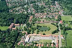 Aerial view of Měšice | |
.gif) Flag _CoA_CZ.gif) Coat of arms | |
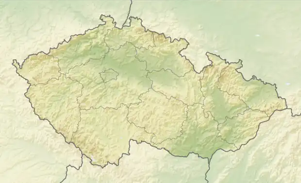 Měšice Location in the Czech Republic | |
| Coordinates: 50°11′53″N 14°31′12″E / 50.19806°N 14.52000°E | |
| Country | |
| Region | Central Bohemian |
| District | Prague-East |
| First mentioned | 1294 |
| Area | |
| • Total | 4.43 km2 (1.71 sq mi) |
| Elevation | 203 m (666 ft) |
| Population (2023-01-01)[1] | |
| • Total | 2,142 |
| • Density | 480/km2 (1,300/sq mi) |
| Time zone | UTC+1 (CET) |
| • Summer (DST) | UTC+2 (CEST) |
| Postal code | 250 64 |
| Website | www |
Měšice is a municipality and village in Prague-East District in the Central Bohemian Region of the Czech Republic. It has about 2,100 inhabitants.
Geography
Měšice is located about 9 kilometres (6 mi) north of Prague. It lies in a flat landscape of the Central Elbe Table.
History

The first written mention of Měšice is from 1294. In 1434, a stone fortress was built here. The Měšice Castle was built in 1767–1775. In 1871–1872, the railway to Všetaty was built, but the connection with Prague was not finished until 1888.[2]
Transport
Měšice lies on the Prague–Mělník railway line.
Sights
The Měšice Castle is the main landmark of Měšice. It is built in the Rococo style with Neoclassical elements and contains remarkable sculptural and painterly decoration. It includes an English landscape garden with rare trees and the oldest lightning rod in Bohemia, which was installed in 1775. Today a private medical facility (Centre of Integrated Oncological Care) resides there.[3][4]
References
- ↑ "Population of Municipalities – 1 January 2023". Czech Statistical Office. 2023-05-23.
- ↑ "Historie obce" (in Czech). Obec Měšice. Retrieved 2021-06-21.
- ↑ "O obci" (in Czech). Obec Měšice. Retrieved 2021-06-21.
- ↑ "Zámek v Měšicích nedaleko Prahy". CzechTourism. Retrieved 2021-09-08.