Malicorne-sur-Sarthe | |
|---|---|
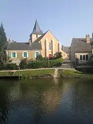 St Silvester's church | |
Location of Malicorne-sur-Sarthe | |
 Malicorne-sur-Sarthe 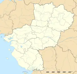 Malicorne-sur-Sarthe | |
| Coordinates: 47°48′52″N 0°05′01″W / 47.8144°N 0.0836°W | |
| Country | France |
| Region | Pays de la Loire |
| Department | Sarthe |
| Arrondissement | La Flèche |
| Canton | La Suze-sur-Sarthe |
| Intercommunality | CC du Val de Sarthe |
| Government | |
| • Mayor (2020–2026) | Carole Roger[1] |
| Area 1 | 15.13 km2 (5.84 sq mi) |
| Population | 1,882 |
| • Density | 120/km2 (320/sq mi) |
| Demonym(s) | Malicornais, Malicornaise |
| Time zone | UTC+01:00 (CET) |
| • Summer (DST) | UTC+02:00 (CEST) |
| INSEE/Postal code | 72179 /72270 |
| Elevation | 28–70 m (92–230 ft) |
| 1 French Land Register data, which excludes lakes, ponds, glaciers > 1 km2 (0.386 sq mi or 247 acres) and river estuaries. | |
Malicorne-sur-Sarthe (French pronunciation: [malikɔʁn syʁ saʁt], literally Malicorne on Sarthe) is a commune in the Sarthe department in the region of Pays de la Loire in north-western France.
See also
- Communes of the Sarthe department
- Malicorne (band), a musical group named after the commune
References
- ↑ "Répertoire national des élus: les maires" (in French). data.gouv.fr, Plateforme ouverte des données publiques françaises. 13 September 2022.
- ↑ "Populations légales 2021". The National Institute of Statistics and Economic Studies. 28 December 2023.
Wikimedia Commons has media related to Malicorne-sur-Sarthe.
This article is issued from Wikipedia. The text is licensed under Creative Commons - Attribution - Sharealike. Additional terms may apply for the media files.