Rongères | |
|---|---|
.jpg.webp) The church in Rongères | |
Location of Rongères | |
 Rongères  Rongères | |
| Coordinates: 46°17′42″N 3°27′04″E / 46.295°N 3.4511°E | |
| Country | France |
| Region | Auvergne-Rhône-Alpes |
| Department | Allier |
| Arrondissement | Vichy |
| Canton | Saint-Pourçain-sur-Sioule |
| Government | |
| • Mayor (2020–2026) | Christophe Minet[1] |
| Area 1 | 8.95 km2 (3.46 sq mi) |
| Population | 544 |
| • Density | 61/km2 (160/sq mi) |
| Time zone | UTC+01:00 (CET) |
| • Summer (DST) | UTC+02:00 (CEST) |
| INSEE/Postal code | 03215 /03150 |
| Elevation | 242–305 m (794–1,001 ft) (avg. 275 m or 902 ft) |
| 1 French Land Register data, which excludes lakes, ponds, glaciers > 1 km2 (0.386 sq mi or 247 acres) and river estuaries. | |
Rongères (French pronunciation: [ʁɔ̃ʒɛʁ]; Occitan: Rongèiras) is a commune in the Allier department in Auvergne in central France.
Population
| Year | Pop. | ±% |
|---|---|---|
| 1962 | 423 | — |
| 1968 | 444 | +5.0% |
| 1975 | 430 | −3.2% |
| 1982 | 509 | +18.4% |
| 1990 | 570 | +12.0% |
| 1999 | 566 | −0.7% |
| 2008 | 551 | −2.7% |
| 2012 | 595 | +8.0% |
| Source: INSEE (1968–2012) | ||
Gallery
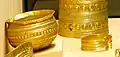 Bronze Age gold bowl and bracelet found in Rongères, Tumulus culture, c. 1400 BC.[3]
See also
References
- ↑ "Répertoire national des élus: les maires". data.gouv.fr, Plateforme ouverte des données publiques françaises (in French). 2 December 2020.
- ↑ "Populations légales 2021". The National Institute of Statistics and Economic Studies. 28 December 2023.
- ↑ "Trésor de Rongères". Musée d'Archéologie Nationale.
Wikimedia Commons has media related to Rongères.
This article is issued from Wikipedia. The text is licensed under Creative Commons - Attribution - Sharealike. Additional terms may apply for the media files.