Saint-Bonnet-de-Rochefort | |
|---|---|
.jpg.webp) Chateau of Rochefort | |
 Coat of arms | |
Location of Saint-Bonnet-de-Rochefort | |
 Saint-Bonnet-de-Rochefort  Saint-Bonnet-de-Rochefort | |
| Coordinates: 46°08′50″N 3°08′21″E / 46.1472°N 3.1392°E | |
| Country | France |
| Region | Auvergne-Rhône-Alpes |
| Department | Allier |
| Arrondissement | Vichy |
| Canton | Gannat |
| Intercommunality | Saint-Pourçain Sioule Limagne |
| Government | |
| • Mayor (2020–2026) | Henri Giraud[1] |
| Area 1 | 16.36 km2 (6.32 sq mi) |
| Population | 718 |
| • Density | 44/km2 (110/sq mi) |
| Time zone | UTC+01:00 (CET) |
| • Summer (DST) | UTC+02:00 (CEST) |
| INSEE/Postal code | 03220 /03800 |
| Elevation | 290–412 m (951–1,352 ft) (avg. 334 m or 1,096 ft) |
| 1 French Land Register data, which excludes lakes, ponds, glaciers > 1 km2 (0.386 sq mi or 247 acres) and river estuaries. | |
Saint-Bonnet-de-Rochefort (French pronunciation: [sɛ̃ bɔnɛ də ʁɔʃfɔʁ]; Auvergnat: Sant Bonet de Ròchafòrt) is a commune in the Allier department in Auvergne-Rhône-Alpes in central France.
Geography
Saint-Bonnet-de-Rochefort is located in the south of the Allier department, 9 kilometres (5.6 mi) of Gannat, 3 kilometres (1.9 mi) of Vicq by departmental road 37; 5 kilometres (3.1 mi) of Ébreuil and Charroux by D35.
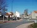 Departmental road 35 passing town centre.
Population
| Year | Pop. | ±% |
|---|---|---|
| 1962 | 700 | — |
| 1968 | 701 | +0.1% |
| 1975 | 669 | −4.6% |
| 1982 | 715 | +6.9% |
| 1990 | 712 | −0.4% |
| 1999 | 656 | −7.9% |
| 2008 | 647 | −1.4% |
| 2013 | 663 | +2.5% |
| Source: INSEE (1968–2013) | ||
See also
References
- ↑ "Répertoire national des élus: les maires" (in French). data.gouv.fr, Plateforme ouverte des données publiques françaises. 13 September 2022.
- ↑ "Populations légales 2021". The National Institute of Statistics and Economic Studies. 28 December 2023.
Wikimedia Commons has media related to Saint-Bonnet-de-Rochefort.
This article is issued from Wikipedia. The text is licensed under Creative Commons - Attribution - Sharealike. Additional terms may apply for the media files.